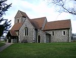
Chipperfield
Civil parishes in HertfordshireDacorumUse British English from December 2014Villages in Hertfordshire

Chipperfield is a village and civil parish in the Dacorum district of Hertfordshire, England, approximately five miles southwest of Hemel Hempstead and five miles north of Watford. It stands on a chalk plateau at the edge of the Chiltern Hills, between 130 and 160 metres above sea level. The village green is at the centre of Chipperfield on the edge of the 117 acre Chipperfield Common. The rural parish includes the hamlet of Tower Hill.
Excerpt from the Wikipedia article Chipperfield (License: CC BY-SA 3.0, Authors, Images).Chipperfield
Kings Lane, Dacorum Chipperfield
Geographical coordinates (GPS) Address Nearby Places Show on map
Geographical coordinates (GPS)
| Latitude | Longitude |
|---|---|
| N 51.7039 ° | E -0.4906 ° |
Address
Kings Lane
Kings Lane
WD4 9DT Dacorum, Chipperfield
England, United Kingdom
Open on Google Maps


