Sarratt Bottom nature reserve
Meadows in HertfordshireSites of Special Scientific Interest in Hertfordshire

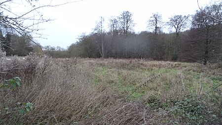
Sarratt Bottom nature Reserve in Hertfordshire is a 3.2-hectare (7.9-acre) biological Site of Special Scientific Interest. The site is a meadow beside the River Chess. It is an example of damp grassland which has been traditionally managed for grazing. There are also areas of swamp and marsh. The main plants in grassland areas include sweet vernal grass and meadow foxtail, and marsh horsetail and common spike-rush are common in damper areas. The site has hedgehogs and a wide variety of wetland birds and invertebrates.There is no public access but the site can be viewed from Moor Lane. The local planning authority is Three Rivers District Council.
Excerpt from the Wikipedia article Sarratt Bottom nature reserve (License: CC BY-SA 3.0, Authors, Images).Sarratt Bottom nature reserve
Dawes Lane, Three Rivers Sarratt
Geographical coordinates (GPS) Address Nearby Places Show on map
Geographical coordinates (GPS)
| Latitude | Longitude |
|---|---|
| N 51.6794 ° | E -0.51022 ° |
Address
Dawes Lane
Dawes Lane
WD3 6DA Three Rivers, Sarratt
England, United Kingdom
Open on Google Maps


