Cha Kwo Ling

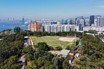
Cha Kwo Ling (Chinese: 茶果嶺) is a hill in the eastern New Kowloon area of Hong Kong, and the area around it. It is adjacent to Victoria Harbour and located to the west of Yau Tong and southwest of Lam Tin. Administratively, it belongs to the Kwun Tong District. The northeastern entrance to the Eastern Harbour Crossing is located in this area. The Cha Kwo Ling Village (茶果嶺村), described as one of the last squatter villages in Hong Kong, has a population of approximately 2,400. It is located approximately 1.4 km (0.87 mi) northwest of Lei Yue Mun, adjacent to the Laguna City development. It lies at the foot of the hill and stretches along Cha Kwo Ling Road, which was built on reclaimed land and separates the village from the coast. In the 2019 and 2020 policy addresses, the chief executive stated that the government intends to take back possession of the Cha Kwo Ling Village and to redevelop the land into high-density public housing.Cha Kwo Ling derives its name from the abundance of macaranga tanarius in the area, the leaves of which are used in the process of making cha kwo, a traditional Hakka snack.
Excerpt from the Wikipedia article Cha Kwo Ling (License: CC BY-SA 3.0, Authors, Images).Cha Kwo Ling
Sin Fat Road, Kowloon Sai Tso Wan (Kwun Tong District)
Geographical coordinates (GPS) Address Nearby Places Show on map
 Continue reading on Wikipedia
 Geographical coordinates (GPS)
| Latitude | Longitude |
|---|---|
| N 22.3037 ° | E 114.231 ° |
Address
晒草灣遊樂場 Sai Tso Wan Recreation Ground
Sin Fat Road
000000 Kowloon, Sai Tso Wan (Kwun Tong District)
Hong Kong, China
Open on Google Maps