Lam Tin

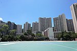
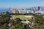
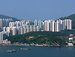
Lam Tin is an area in the Kwun Tong District in southeastern New Kowloon, Hong Kong. Lam Tin is primarily a residential area but also hosts a major transport interchange and several shopping attractions. Lam Tin was once a large field in the vicinity of Kowloon Bay. During the Song dynasty, it was a site of salt production. Since the 1980s, a number of housing estates were constructed in Lam Tin. A high-density residential district built on a coastal knoll, Lam Tin hosts residential housing estates, transport infrastructure, mass-transit facilities, shopping centres, recreational areas and many other buildings and structures. It is home to 130,000 residents, making up a fifth of Kwun Tong District's population.
Excerpt from the Wikipedia article Lam Tin (License: CC BY-SA 3.0, Authors, Images).Lam Tin
Tak Tin Street, Kowloon Lam Tin (Kwun Tong District)
Geographical coordinates (GPS) Address Nearby Places Show on map
 Continue reading on Wikipedia
 Geographical coordinates (GPS)
| Latitude | Longitude |
|---|---|
| N 22.309444444444 ° | E 114.23611111111 ° |
Address
藍田配水庫 Lam Tin Service Reservoir
Tak Tin Street
000000 Kowloon, Lam Tin (Kwun Tong District)
Hong Kong, China
Open on Google Maps