Sai Tso Wan, Tsing Yi
Bays of Hong KongHong Kong geography stubsTsing Yi

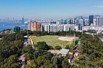
Sai Tso Wan (Chinese: 茜草灣 or 西草灣) is a former bay in the west shore near the centre of Tsing Yi Island, Hong Kong. Its reclamation started in the 1960s. The bay has several heavy industry facilities, such oil storages and docks. The Chinese name Sai Tso Wan (茜草灣) means the bay of Rubia cordifolia (茜草). Correctly, pronounced as Sin Tso Wan rather than Sai Tso Wan. For the sake of convenience, the Chinese name is sometimes written using characters with the same pronunciation, Sai Tso Wan (西草灣), which means the bay of west grass.
Excerpt from the Wikipedia article Sai Tso Wan, Tsing Yi (License: CC BY-SA 3.0, Authors, Images).Sai Tso Wan, Tsing Yi
Tseung Kwan O-Lam Tin Tunnel, Kowloon Lam Tin (Kwun Tong District)
Geographical coordinates (GPS) Address Nearby Places Show on map
 Continue reading on Wikipedia
 Geographical coordinates (GPS)
| Latitude | Longitude |
|---|---|
| N 22.3026 ° | E 114.2335 ° |
Address
藍田交匯處 Lam Tin Interchange
Tseung Kwan O-Lam Tin Tunnel
000000 Kowloon, Lam Tin (Kwun Tong District)
Hong Kong, China
Open on Google Maps