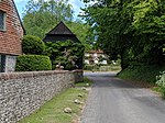
Southrope
AC with 0 elementsHampshire geography stubsVillages in Hampshire

Southrope is a hamlet in the civil parish of Herriard, Hampshire. It has one pub, named the Fur and Feathers. The hamlet was once considered a part of the civil parish Bentworth, until the late 19th century. Its nearest town is Alton, which lies approximately 5.8 miles (9.3 km) south-east from the hamlet. The hamlet's toponym derives from Old English Sūþrop, meaning south village.
Excerpt from the Wikipedia article Southrope (License: CC BY-SA 3.0, Authors, Images).Southrope
Lee Farm Road, Basingstoke and Deane
Geographical coordinates (GPS) Address Nearby Places Show on map
Geographical coordinates (GPS)
| Latitude | Longitude |
|---|---|
| N 51.2 ° | E -1.0333 ° |
Address
Lee Farm Road
Lee Farm Road
RG25 2PE Basingstoke and Deane
England, United Kingdom
Open on Google Maps


