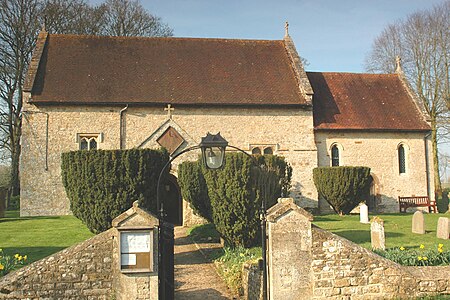
Cottisford

Cottisford is a village and civil parish in Oxfordshire, about 3.5 miles (5.6 km) south of Brackley in neighbouring Northamptonshire. The parish's northern and northwestern boundaries form part of the boundary between the two counties. The parish includes the hamlet of Juniper Hill about 1 mile (1.6 km) northwest of Cottisford. The 2011 Census recorded the parish's population as 216.The village stands beside Crowell Brook, which is a stream that passes the villages of Hethe, Fringford and Godington before entering Buckinghamshire where it becomes part of Padbury Brook, a tributary of the Great Ouse. Cottisford's toponym refers to a former ford across Crowell Brook. In the 13th century the village was called Wolfheysford or Urlfesford.
Excerpt from the Wikipedia article Cottisford (License: CC BY-SA 3.0, Authors, Images).Cottisford
Cherwell District
Geographical coordinates (GPS) Address Nearby Places Show on map
Geographical coordinates (GPS)
| Latitude | Longitude |
|---|---|
| N 51.979 ° | E -1.14 ° |
Address
NN13 5SA Cherwell District
England, United Kingdom
Open on Google Maps


