place

Kai Tak Nullah

Kowloon City DistrictRivers of Hong KongSubterranean Hong KongVague or ambiguous time from September 2021Wong Tai Sin District
Nga Tsin Wai Tsuen 2009 03

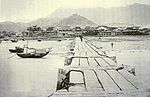
The Kai Tak Nullah (Chinese: 啟德明渠, also known as the Kaitak River (啟德河)) is a nullah or watercourse that collects water from the rivers and streams flowing from the hills in northern New Kowloon. It empties into a narrow channel leading into the Kwun Tong Typhoon Shelter. Part of the nullah is covered by roads and other facilities. The Kai Tak Nullah is about 2.4 km (1+173⁄352 mi) in length. It flows from Po Kong Village Road along Choi Hung Road, pass Tung Tau Estate and San Po Kong, into Kai Tak Development Area before discharging into the Victoria Harbour at the Kwun Tong Typhoon Shelter. It has an upstream and a midstream. The nullah is one of the major flood relief drainage channels in the East Kowloon area. The improvement work of Kai Tak Nullah has been overseen by the Civil Engineering and Development Department since March 2012, aiming to turn the nullah into an attractive green river corridor. It is anticipated to be fully completed before 2021.

Excerpt from the Wikipedia article Kai Tak Nullah (License: CC BY-SA 3.0, Authors, Images).

Kai Tak Nullah
Chun Chi Lane North, Kowloon Kai Tak (Kowloon City District)

Geographical coordinates (GPS) Address Nearby Places
placeShow on map

Wikipedia: Kai Tak NullahContinue reading on Wikipedia

Geographical coordinates (GPS)

Latitude Longitude
N 22.3298 ° E 114.1977 °
placeShow on map

Address

啟德 Kai Tak

Chun Chi Lane North
Kowloon, Kai Tak (Kowloon City District)
Hong Kong, China
mapOpen on Google Maps

Nga Tsin Wai Tsuen 2009 03
Share experience

Nearby Places

Kai Tak Development
Kai Tak Development

The Kai Tak Development (Chinese: 啟德發展計劃), abbreviated as "KTD" and formerly called South East Kowloon Development (東南九龍發展計劃), refers to the redevelopment of the former Kai Tak Airport site in Kai Tak, Kowloon, Hong Kong. After the airport relocated to Chek Lap Kok in 1998, the Hong Kong government planned for urban development on the old airport site. The plan calls for a multi-purpose sports complex, a metro park, the Kai Tak Cruise Terminal, a hotel, a housing estate, and commercial and entertainment construction projects over an area of more than 328 hectares (810 acres). The plan also covered nearby development in areas including Ma Tau Wai, Kowloon City, San Po Kong, Kowloon Bay and Kwun Tong. The planned population is 86,000 people, accommodated in 30,000 housing units, including 13,000 constructed as part of public housing estates. The total gross floor area is over 14,400,000 square feet (1,340,000 m2) with over 110 hectares (270 acres) of open space. The total cost for the development is about HK$100 billion. After several years of planning and discussion, and the decision of a judicial review on Central and Wan Chai Reclamation, the Hong Kong government restarted KTD review and planning in 2004. The Executive Council passed the revised development plan and restarted the project. According to the development plan, the first stage projects finished in or before 2013. The second stage projects will be finished in or before 2016 and the final stage projects will be completed in or before 2021.

Kai Tak Airport
Kai Tak Airport

Kai Tak Airport (IATA: HKG, ICAO: VHHH) was the international airport of Hong Kong from 1925 until 1998. Officially known as Hong Kong International Airport from 1954 to 6 July 1998, it is often referred to as Hong Kong International Airport, Kai Tak, or simply Kai Tak and Kai Tak International Airport, to distinguish it from its successor, which may be referred to as Chek Lap Kok International Airport, built on reclaimed and levelled land around the islands of Chek Lap Kok and Lam Chau, 30 kilometres (19 mi) to the west.Because of the geography of the area positioning the airport with water on three sides of the runway, with Kowloon City's residential apartment complexes and 2000+ft mountains to the north-east of the airport, aircraft could not fly over the mountains and quickly drop in for a final. Instead, aircraft had to fly above Victoria Harbour and Kowloon City, passing north of Mong Kok's Bishop Hill. After passing Bishop Hill, pilots would see Checkerboard Hill with a large red and white checkerboard pattern. Once the pattern was sighted and identified, aircraft made a low-altitude (sub-600 ft) 47° right-hand turn, ending with a short final and touchdown. For pilots, this airport was technically demanding, as the approach could not be flown by aircraft instruments, but had to be flown visually because of the right-hand turn required. The History Channel program Most Extreme Airports ranked it as the 6th most dangerous airport in the world.The airport was home to Hong Kong's international carrier Cathay Pacific, as well as regional carrier Dragonair (now known as Cathay Dragon), freight airline Air Hong Kong and Hong Kong Airways. The airport was also home to the former RAF Kai Tak.