place

LaGuardia Airport

1939 establishments in New York CityAirfields of the United States Army Air Forces Air Transport Command in North AmericaAirfields of the United States Army Air Forces in New York (state)Airports established in 1939Airports in Queens, New York
East Elmhurst, QueensLaGuardia AirportPort Authority of New York and New JerseyUse mdy dates from March 2022Vague or ambiguous time from October 2017Works Progress Administration in New York City
LaGuardia Airport
LaGuardia Airport

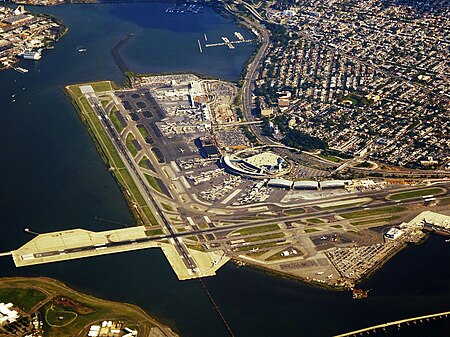
LaGuardia Airport (IATA: LGA, ICAO: KLGA, FAA LID: LGA) is a civil airport in East Elmhurst, Queens, New York City. Covering 680 acres (280 ha) in its present form, the facility was established in 1929 and began operating as a public airport in 1939. It is named after former New York City Mayor Fiorello La Guardia. The airport primarily accommodates airline service to domestic (and limited international) destinations. As of 2019, it was the third-busiest airport in the New York metropolitan area behind John F. Kennedy and Newark airports, and the twenty-first busiest in the United States by passenger volume. While the airport is a hub for both American Airlines and Delta Air Lines, commercial service is strictly governed by unique regulations including a curfew, a slot system, and a "perimeter rule" prohibiting most nonstop flights to or from destinations greater than 1,500 miles (2,400 km).Throughout the 2000s and 2010s, LaGuardia was notable for having obsolete and dirty facilities, inefficient air operations, and poor customer service metrics. Responding to these criticisms, the Port Authority of New York and New Jersey (PANYNJ) in 2015 announced a multibillion-dollar reconstruction of the airport's passenger infrastructure, which is expected to be complete by 2025.

Excerpt from the Wikipedia article LaGuardia Airport (License: CC BY-SA 3.0, Authors, Images).

LaGuardia Airport
Bowery Bay Boulevard, New York Queens

Geographical coordinates (GPS) Address Website External links Nearby Places
placeShow on map

Wikipedia: LaGuardia AirportContinue reading on Wikipedia

Geographical coordinates (GPS)

Latitude Longitude
N 40.775 ° E -73.875 °
placeShow on map

Address

LaGuardia Airport (LGA)

Bowery Bay Boulevard
11371 New York, Queens
New York, United States
mapOpen on Google Maps

Website
laguardiaairport.com

linkVisit website

linkWikiData (Q319654)
linkOpenStreetMap (198597589)

LaGuardia Airport
LaGuardia Airport
Share experience

Nearby Places

Marine Air Terminal
Marine Air Terminal

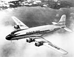
The Marine Air Terminal (also known as Terminal A) is an airport terminal located at LaGuardia Airport in Queens, New York City. Its main building, designed in the Art Deco style by William Delano of the firm Delano & Aldrich, opened in 1940. The terminal was built to handle Pan Am's fleet of flying boats, the Boeing 314 Clippers, which landed on the nearby Bowery Bay. Technological advances after World War II made the Clippers obsolete, and the Marine Air Terminal was renovated in 1946 to serve conventional planes. As of 2022, the terminal is used by Spirit Airlines flights to various destinations around the US. The Marine Air Terminal was LaGuardia Airport's original terminal for overseas flights. It was highly popular in the 1940s, when LaGuardia was the only major airport in the U.S. which offered regular flights to Europe. Traffic dropped drastically after the larger Idlewild Airport opened in 1948, and Clippers stopped serving the terminal in 1952. The terminal then served as the airport's general aviation terminal for more than three decades, except for a short period in the 1950s, when it was used by Northeast Airlines. The Pan Am Shuttle service started operating from Marine Air Terminal in 1986. Delta Air Lines took over the service in 1991, operating Delta Shuttle flights from the terminal until 2017, after which it was used by various carriers. The terminal has been renovated multiple times throughout its history. The main terminal building consists of a two-story circular core with a projecting entrance pavilion and a pair of two-story wings. The brick facade is painted buff, with black details, and contains a frieze that depicts flying fish. The three-story rectangular entrance pavilion contains a canopy and a set of doors leading to the terminal's main rotunda. The rotunda contains marble floors and walls, as well as the Flight mural by James Brooks. Both the interior and the exterior of the main building were declared New York City Landmarks in 1980, and it was added to the National Register of Historic Places in 1982. In addition, there was a hangar for seaplanes next to the main building, which has been converted into a garage for snow-removal vehicles.

One Room Schoolhouse Park

One Room Schoolhouse Park is a small park located on the southeast corner of Astoria Boulevard and 90th Street in the East Elmhurst neighborhood of Queens, New York City. Its name recalls the site of Queens's last one-room schoolhouse, demolished in 1934. The schoolhouse was built only five years after New York State required compulsory education for children in 1874. Last called P.S. 10, the school was also known as the Bowery Bay School, after an earlier school established in 1734, and as the Frogtown School. Frogtown was a poor community located in a swampy area north of Astoria Boulevard, near the present-day LaGuardia Airport. Emma Fagan headed the school from 1879 to 1910. The 15 by 28 foot classroom had capacity for fifty-two students divided into six classes. The six rows of desks were arranged according to the age and ability of the students. The beginners were seated at the smaller desks in the front, while the more advanced students occupied the back rows. In the center of the classroom, a stove with a pipe extending to the roof that kept the space warm during winter. By 1910, the expanding needs of immigrant populations and the reform movement that created the public education system had rendered one-room schoolhouses obsolete. The schoolhouse closed in 1925, but a temporary school building was still in use at the site when Parks acquired the .14-acre property from the Board of Education in 1934. Increased population in the neighborhood necessitated the construction of a new playground that opened to the public in December 1935. Subsequent decades saw the playground transformed into a sitting area. In 2015, the City Council allocated funding for the restoration of this park. The redesign of the park will commence following informational sessions to incorporate public input on the park’s features. Work on the renovation started in 2019.