place

Dorothea quarry

Cornish enginesDiving quarries in the United KingdomDyffryn NantlleLlanllyfniPreserved beam engines
Slate mines in GwyneddUse British English from December 2020
DorotheaQuarry 01s
DorotheaQuarry 01s

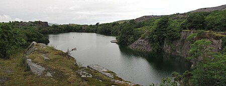
Dorothea quarry is a disused slate quarry in the Nantlle Valley area in North Wales. It covers a large area near the village of Talysarn and contains three flooded deep lakes.

Excerpt from the Wikipedia article Dorothea quarry (License: CC BY-SA 3.0, Authors, Images).

Dorothea quarry
Ffordd y Parc,

Geographical coordinates (GPS) Address Nearby Places
placeShow on map

Wikipedia: Dorothea quarryContinue reading on Wikipedia

Geographical coordinates (GPS)

Latitude Longitude
N 53.025 ° E -4.2833333333333 °
placeShow on map

Address

Ffordd y Parc

Ffordd y Parc
LL54 6DP , Llanllyfni
Wales, United Kingdom
mapOpen on Google Maps

DorotheaQuarry 01s
DorotheaQuarry 01s
Share experience

Nearby Places

Nantlle Valley
Nantlle Valley

The Nantlle Valley (Welsh: Dyffryn Nantlle, IPA: [ˈdəfrɨn ˈnantɬɛ]) is an area in Gwynedd, North Wales, characterised by its numerous small settlements. The area is also historically important geologically, and featured in one of the most contentious disputes of the 19th century, between the 'Diluvialists' who believed in the Biblical flood, and the ‘Glacialists’, who supported the Glacial Theory, which was substantially established by studies of the drift sediments on Moel Tryfan.Between 85 and 90% of the population of the Nantlle Valley speak Welsh as their first language.Some of the communities came into being as a result of slate quarrying in the late eighteenth or early nineteenth centuries, and some have a history stretching back to antiquity. There are Iron Age forts at Caer Engan in Pen-y-groes and on the coast at Dinas Dinlle and evidence of Bronze Age settlement on the higher ground. The valley was important during the Middle Ages, with a clas or ecclesiastical college developed at Clynnog Fawr.The Glynllifon estate can trace its foundation historically to the 8th century and there is evidence of occupation on the site going back to the Iron Age.There were a number of quarries in the valley, the largest being the Dorothea and Pen yr Orsedd quarries. Although the major quarries are worked out, there remains demand for slate waste for garden decoration.In 1991, Antur Nantlle Cyf was established as a community enterprise to work for the benefit of the Nantlle Valley and its surrounding area.

Penygroes railway station

Penygroes railway station was located in Penygroes, Gwynedd, Wales.The narrow gauge, horse-drawn Nantlle Railway had a station near the site from 1856. From the outset timetables appeared regularly in the "Carnarvon & Denbigh Herald" and in Bradshaw from October 1856. In 1865 the narrow gauge line was closed, to be replaced and updated to standard gauge with contemporary facilities. It reopened in its eventual form in 1867 and closed in December 1964. The station served as the junction station for the short branch to Nantlle which was overlain in 1872 on part of the former Nantlle Railway route, but its main purpose was for traffic on the former Carnarvonshire Railway line from Caernarvon to Afon Wen and beyond.When the line and station were first opened in 1867 a locomotive was hired from the Cambrian Railways. A Cambrian driver, who had never been over the line before, was retained to drive the first directors' inspection special from Afon Wen to Carnarvon (Pant). On the return journey the loco ran short of coal and ran out of steam at Penygroes. There was some peat in a nearby field, which the crew dug and the directors carried to the engine enabling steam to be raised.The passenger service along the Nantlle Branch was withdrawn in 1932, though excursions continued until 1939. The station and line closed on 7 December 1964 as recommended in the Beeching Report. The station building and footbridge remained in place, but increasingly derelict, until at least 1970.