Ferndale, Rhondda Cynon Taf
Communities in Rhondda Cynon TafFormer wards of Rhondda Cynon TafRhondda ValleyTowns in Rhondda Cynon Taf

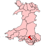
Ferndale (Welsh: Glynrhedynog) is a town and community located in the Rhondda Valley in the county borough of Rhondda Cynon Taf, Wales. Neighbouring villages are Blaenllechau, Maerdy and Tylorstown. Ferndale was industrialised in the mid-19th century. The first coal mine shaft was sunk in 1857 and was the first community to be intensively industrialised in the Rhondda Valley.
Excerpt from the Wikipedia article Ferndale, Rhondda Cynon Taf (License: CC BY-SA 3.0, Authors, Images).Ferndale, Rhondda Cynon Taf
High Street,
Geographical coordinates (GPS) Address Nearby Places Show on map
Geographical coordinates (GPS)
| Latitude | Longitude |
|---|---|
| N 51.661 ° | E -3.448 ° |
Address
High Street
High Street
CF43 4RL , Blaenllechau
Wales, United Kingdom
Open on Google Maps


