Cefn Gwyngul
Mountains and hills of Rhondda Cynon Taf
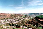
Cefn Gwyngul is a long broad ridge to the east of the Rhondda Fach valley in Rhondda Cynon Taf County Borough in South Wales. Its 470m high summit is marked by an ancient cairn known as Carn-y-Pigwn, on which is a more recent trig point. Much of the hill is cloaked by modern forestry plantations though its southwestern flank between Porth and Ferndale has not been coniferised. The earthworks of a Roman camp remain on the ridge at OS grid ref ST 002982.
Excerpt from the Wikipedia article Cefn Gwyngul (License: CC BY-SA 3.0, Authors).Cefn Gwyngul
Geographical coordinates (GPS) Address Nearby Places Show on map
Geographical coordinates (GPS)
| Latitude | Longitude |
|---|---|
| N 51.6668 ° | E -3.4301 ° |
Address
Ferndale
, Ferndale
Wales, United Kingdom
Open on Google Maps


