Barregarrow
All image captions for cleanupImage captions for cleanup/Without examplesImage captions for cleanup from December 2019Roads in the Isle of ManUse British English from August 2017
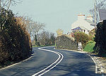
Barregarrow (Manx: Bayr Garroo [bi ˈɡa(ː)ɾo]) is a district located between the 13th milestone and 14th milestones on the A3 Castletown to Ramsey road including the area of the Barregarrow cross-road junction and the C4 Ballaleigh Road and B10 Sartfield (Brandywell) or former Barregarrow mountain gate road in the parish of Kirk Michael in the Isle of Man.
Excerpt from the Wikipedia article Barregarrow (License: CC BY-SA 3.0, Authors).Barregarrow
Ballaleigh Road, Michael
Geographical coordinates (GPS) Address Nearby Places Show on map
 Continue reading on Wikipedia
 Geographical coordinates (GPS)
| Latitude | Longitude |
|---|---|
| N 54.260833333333 ° | E -4.5815 ° |
Address
Barregarrow Chapel
Ballaleigh Road
Michael
Isle of Man
Open on Google Maps