place

Maryhill, New Zealand

Suburbs of DunedinUse New Zealand English from January 2022

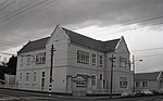
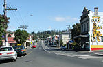
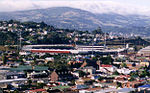
Maryhill is a residential suburb of the New Zealand city of Dunedin. It is located on a ridge to the southwest of the central city between the suburbs of Mornington, Kenmure, and Caversham. The smaller suburb of Balaclava lies immediately to its west. Maryhill is believed to take its name from a district in the city of Glasgow in Scotland, where many of the early settlers of the suburb originated. In this regard it is unusual among Dunedin suburbs, many of which are named for suburbs of Edinburgh - Maryhill and the nearby Little Paisley are the only suburbs named for Glaswegian locations, and the latter is an old name rarely used today. A second theory is that Maryhill was named in honour of Mary, the wife of early Dunedin settler John Bathgate.The main road in Maryhill is Glenpark Avenue, which runs south from a series of small streets which connect it with Mailer Street Mornington. At its southern end, it links with a tortuous zig-zag road, Lancefield Street, which leads to the suburb of Caversham. Several roads cross Glenpark Avenue; notable among them are Maryhill Terrace and Glen Road. These connect with Caversham at The Glen, in Maryhill's southwestern corner. Elgin Road, which runs parallel with Glenpark Avenue and lies at roughly the border of Maryhill, Mornington, and Kenmure, forms a major access road at Maryhill's western edge. This route links with Mailer Street and Kenmure Road at its northernmost point, and with Mornington Road at its southern end. Little Paisley is an old name for an area close to the boundary of Maryhill and Mornington, between the top of Glen Road and Eglinton Road close to Dunedin Southern Cemetery. It gained this name in the early years of Dunedin's settlement, was settled by weavers from Paisley. The name is rarely used today. Maryhill was connected from 1855 to 1955 to the Dunedin cable tramway system via the Maryhill Extension. The line, which followed Glenpark Avenue from Mornington, was perfectly straight, and was sometimes referred to as The Big Dipper because of its undulating course. Maryhill's notable residents have included writer and publisher Sir Alfred Hamish Reed.

Excerpt from the Wikipedia article Maryhill, New Zealand (License: CC BY-SA 3.0, Authors).

Maryhill, New Zealand
Maryhill Terrace, Dunedin Maryhill

Geographical coordinates (GPS) Address Nearby Places
placeShow on map

Wikipedia: Maryhill, New ZealandContinue reading on Wikipedia

Geographical coordinates (GPS)

Latitude Longitude
N -45.8884 ° E 170.4794 °
placeShow on map

Address

Maryhill Terrace

Maryhill Terrace
9011 Dunedin, Maryhill
Otago, New Zealand
mapOpen on Google Maps

Share experience

Nearby Places

Mornington, Dunedin
Mornington, Dunedin

Mornington is a suburb of the city of Dunedin, in the South Island of New Zealand. It is situated on hilly slopes 2 kilometres (1.2 mi) to the west of the city centre, the slopes forming part of a ridge which surrounds the heart of the city. According to the 2013 New Zealand census, Mornington has a population of 3,267, a decrease of 126 people since the 2006 census. There were 1,518 males and 1,749 females.The use of the name Mornington for the area was first recorded in 1862. There seems to be some conjecture about the origin of the name – some sources record it as being purely descriptive, with the suburb receiving the first rays of the sunrise. There is some likelihood, however, that it was named by early landholder David Mailer after Mornington, Victoria. Mornington was a separate borough until amalgamation with Dunedin city in 1916Mornington's main streets are Mailer Street, Elgin Road, Glenpark Avenue, Eglinton Road, and Kenmure Road. It is a mainly residential suburb, with a retail area on Mailer Street. The suburb is surrounded by the suburbs of Kenmure to the west, Roslyn to the north, Maryhill to the southwest, Belleknowes to the northeast, and The Glen – divided roughly between Mornington and Caversham in the southeast. To the east lies the City Rise, an area that includes some old grand houses which surround the southern end of the city centre. The Town Belt, a bush-clad green belt dating to the early years of Dunedin's settlement, follows the slopes of the ridge, and lies immediately below Mornington, most prominently to the northeast. Mornington is the home to several sports grounds and teams, and was the site of New Zealand's first golf course, opened in 1872. The Zingari-Richmond Rugby Club is based at Montecillo ground in Eglinton Road. Montecillo, the city's home for war veterans, was moved from Eglinton Road to South Dunedin in the 1990s. Immediately above Montecillo ground is Unity Park, which is a venue for Mornington Football (soccer) club. Unity Park affords panoramic views across the central city, and is the site of a statue of Antarctic explorer Admiral Richard Byrd, commemorating the 1928 departure for the southern continent from Dunedin by Byrd's 1928 expeditionLandmarks within Mornington include the suburb's former post office in Mailer Street, a distinctive building completed in 1905 with small a mock-Byzantine domed tower above the entrance.

Caversham, New Zealand

Caversham is one of the older suburbs of the city of Dunedin, in New Zealand's South Island. It is sited at the western edge of the city's central plain at the mouth of the steep Caversham Valley, which rises to the saddle of Lookout Point. Major road and rail routes south lie nearby; the South Island Main Trunk railway runs through the suburb, and a bypass skirts its main retail area, connecting Dunedin's one-way street system with the Dunedin Southern Motorway. The suburb is linked by several bus routes to its neighbouring suburbs and central Dunedin. The suburb was founded by wealthy pioneer William Henry Valpy, and its name reflects his family connections with the town of Reading, in the English county of Berkshire. Caversham grew rapidly during the Central Otago Gold Rush of the 1860s because of its location on routes south to the Otago hinterland. By the end of the 19th century, Caversham was heavily industrialised, and its population included many skilled or semi-skilled tradespeople. This, combined with the community's strong Protestant roots, led to the area's generally left-leaning political stance. Caversham's early history has been the subject of the Caversham Project, a major historical and archaeological study by the University of Otago. Caversham was a separate borough until 1904, when it was amalgamated with Dunedin city. At a national level, it is part of the Taieri electorate. Caversham is now predominantly residential, with some industrial premises in the east (notably the Hillside Railway Workshops) and a retail district centred on South Road and Hillside Road. Residents are generally of low socio-economic status. Caversham's notable buildings include the heritage listed Lisburn House and several prominent church buildings. Another landmark is the suburb's war memorial, which is the main gate of Caversham School, the suburb's primary school. Caversham also contains a special-needs school. The nearest secondary schools operate in St Clair, 1 kilometre (0.62 mi) to the south. Caversham has strong sporting connections, and is the location of Carisbrook, until recently one of Dunedin's main sports venues. The suburb is home to the Southern Rugby Football Club, and gives its name to Caversham Football Club. Several notable sportspeople have associations with Caversham, among them Test cricketer Clarrie Grimmett and father and son rugby union administrators "Old Vic" and "Young Vic" Cavanagh. Other notable people with Caversham connections include politician Thomas Kay Sidey, architect Edmund Anscombe, and surveyor John Turnbull Thomson.

Calton Hill, New Zealand

Calton Hill is an elevated southern residential suburb of the City of Dunedin in New Zealand's South Island. The suburb is named after Calton Hill in Edinburgh, Scotland, and some of its street names carry similar etymological roots. The suburb was established in the 1900s, as part of the second wave of suburban development in Dunedin. The parent suburb is Caversham, one of Dunedin's (and New Zealand's) oldest suburbs, established two generations prior as part of the first wave of settlement of the area. During the first wave of settlement before Calton Hill was established, it is unclear what modern day Calton Hill was called; possibilities include Caversham Hills or, more informally, John Sidey's farm. Calton Hill is the geographical area bounded by the Dunedin Southern Motorway to the north and the Caversham Valley Forest Reserve beyond; farmland in the south and west that borders Concord and the Burnside industrial area; and an arbitrary eastern border of Corstorphine Road, Sidey Street, Cole Street and South Road (where it terminates near the Dunedin Southern Motorway). The South Island Main Trunk railway and the motorway (part of State Highway 1) further distinguish its northern border. For many of those on the northern and eastern slopes, Calton Hill has views to Mt Cargill (Kapukataumahaka) and Flagstaff (Te Whanaupaki) in the north and the Pacific Ocean in the south-east. To the east, Calton Hill looks over the central plains of Dunedin city with Signal Hill (Te Pahuri o te Rangipohika), the Otago Harbour and Otago Peninsula in the distance. For those on the western slopes, the Kaikorai Valley and Green Island are in immediate view with Saddle Hill and the Taieri Plains beyond.

Kensington, Dunedin
Kensington, Dunedin

Kensington is a small suburb of the New Zealand city of Dunedin, nestled to the south of a hilly spur between the central city and the major suburb of South Dunedin, some 2.4 kilometres (1.5 mi) to the south of the city centre. The suburb was named for the leafy London suburb, possibly by John Hyde Harris, who subdivided the area in the 1860s.Kensington is located on and around King Edward Street, close to the point at which it becomes Princes Street. This is one of Dunedin's main arterial routes, with King Edward Street stretching south to become the main road through South Dunedin, and Princes Street heading north to Dunedin's city centre. The suburb lies at the foot of a spur off Maryhill officially referred to as Montecillo Ridge, and close to the inner city sports ground, the Oval. This 9.3-hectare (23-acre) ground, originally called the Southern Recreation Ground, is now referred to as the Kensington Oval, so as to distinguish it from the University Oval in the north of the city. This ground is actually triangular, but at one time contained a separate oval cricket ground, which gave it its name. Dunedin Southern Cemetery sits on the slope of Montecillo Ridge immediately above Kensington, separated from it by South Road, a main route to Caversham, which joins with Princes Street close to the Oval. These two green areas mark the southernmost extreme of Dunedin's Town Belt, which sweeps around the central city in a broad crescent through the suburbs of Mornington, Belleknowes, Roslyn, Maori Hill, Woodhaugh, and Dunedin North. The lower slopes of Montecillo Ridge were at one time the site of "Hillside", the home of Dunedin city's founding father Captain William Cargill. Though the house is long gone, its name lives on in that of South Dunedin's Hillside Road. Kensington is largely separated from South Dunedin by an overbridge and railway embankment carrying the South Island Main Trunk railway. The long-closed Kensington railway halt was located immediately to the east of the bridge, and accessed by a flight of stairs in one of the bridge's supports, long since sealed up. A newer flyover 200 metres to the north carries State Highway 1 through Kensington, though there are no slip roads connecting the suburb with the highway. This flyover separates Kensington into two distinct parts, a light industrial zone to the south of the flyover, and a residential zone to the north, at the foot of the ridge. A notable feature of Kensington is the city's army drill hall, located in Bridgman Street immediately to the south of State Highway 1.