place

Mornington, Dunedin

1862 establishments in New ZealandSuburbs of DunedinUse New Zealand English from January 2022
Mornington Post Office (former), Dunedin, New Zealand

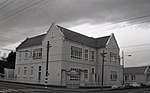
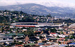
Mornington is a suburb of the city of Dunedin, in the South Island of New Zealand. It is situated on hilly slopes 2 kilometres (1.2 mi) to the west of the city centre, the slopes forming part of a ridge which surrounds the heart of the city. According to the 2013 New Zealand census, Mornington has a population of 3,267, a decrease of 126 people since the 2006 census. There were 1,518 males and 1,749 females.The use of the name Mornington for the area was first recorded in 1862. There seems to be some conjecture about the origin of the name – some sources record it as being purely descriptive, with the suburb receiving the first rays of the sunrise. There is some likelihood, however, that it was named by early landholder David Mailer after Mornington, Victoria. Mornington was a separate borough until amalgamation with Dunedin city in 1916Mornington's main streets are Mailer Street, Elgin Road, Glenpark Avenue, Eglinton Road, and Kenmure Road. It is a mainly residential suburb, with a retail area on Mailer Street. The suburb is surrounded by the suburbs of Kenmure to the west, Roslyn to the north, Maryhill to the southwest, Belleknowes to the northeast, and The Glen – divided roughly between Mornington and Caversham in the southeast. To the east lies the City Rise, an area that includes some old grand houses which surround the southern end of the city centre. The Town Belt, a bush-clad green belt dating to the early years of Dunedin's settlement, follows the slopes of the ridge, and lies immediately below Mornington, most prominently to the northeast. Mornington is the home to several sports grounds and teams, and was the site of New Zealand's first golf course, opened in 1872. The Zingari-Richmond Rugby Club is based at Montecillo ground in Eglinton Road. Montecillo, the city's home for war veterans, was moved from Eglinton Road to South Dunedin in the 1990s. Immediately above Montecillo ground is Unity Park, which is a venue for Mornington Football (soccer) club. Unity Park affords panoramic views across the central city, and is the site of a statue of Antarctic explorer Admiral Richard Byrd, commemorating the 1928 departure for the southern continent from Dunedin by Byrd's 1928 expeditionLandmarks within Mornington include the suburb's former post office in Mailer Street, a distinctive building completed in 1905 with small a mock-Byzantine domed tower above the entrance.

Excerpt from the Wikipedia article Mornington, Dunedin (License: CC BY-SA 3.0, Authors, Images).

Mornington, Dunedin
Durham Street, Dunedin Mornington

Geographical coordinates (GPS) Address Nearby Places
placeShow on map

Wikipedia: Mornington, DunedinContinue reading on Wikipedia

Geographical coordinates (GPS)

Latitude Longitude
N -45.8824 ° E 170.4777 °
placeShow on map

Address

Durham Street

Durham Street
9011 Dunedin, Mornington
Otago, New Zealand
mapOpen on Google Maps

Mornington Post Office (former), Dunedin, New Zealand
Share experience

Nearby Places

Maryhill, New Zealand

Maryhill is a residential suburb of the New Zealand city of Dunedin. It is located on a ridge to the southwest of the central city between the suburbs of Mornington, Kenmure, and Caversham. The smaller suburb of Balaclava lies immediately to its west. Maryhill is believed to take its name from a district in the city of Glasgow in Scotland, where many of the early settlers of the suburb originated. In this regard it is unusual among Dunedin suburbs, many of which are named for suburbs of Edinburgh - Maryhill and the nearby Little Paisley are the only suburbs named for Glaswegian locations, and the latter is an old name rarely used today. A second theory is that Maryhill was named in honour of Mary, the wife of early Dunedin settler John Bathgate.The main road in Maryhill is Glenpark Avenue, which runs south from a series of small streets which connect it with Mailer Street Mornington. At its southern end, it links with a tortuous zig-zag road, Lancefield Street, which leads to the suburb of Caversham. Several roads cross Glenpark Avenue; notable among them are Maryhill Terrace and Glen Road. These connect with Caversham at The Glen, in Maryhill's southwestern corner. Elgin Road, which runs parallel with Glenpark Avenue and lies at roughly the border of Maryhill, Mornington, and Kenmure, forms a major access road at Maryhill's western edge. This route links with Mailer Street and Kenmure Road at its northernmost point, and with Mornington Road at its southern end. Little Paisley is an old name for an area close to the boundary of Maryhill and Mornington, between the top of Glen Road and Eglinton Road close to Dunedin Southern Cemetery. It gained this name in the early years of Dunedin's settlement, was settled by weavers from Paisley. The name is rarely used today. Maryhill was connected from 1855 to 1955 to the Dunedin cable tramway system via the Maryhill Extension. The line, which followed Glenpark Avenue from Mornington, was perfectly straight, and was sometimes referred to as The Big Dipper because of its undulating course. Maryhill's notable residents have included writer and publisher Sir Alfred Hamish Reed.

City Rise
City Rise

City Rise is an inner suburb of the New Zealand city of Dunedin. One of the city's older suburbs, it is, as its name suggests, centred on the slopes which lie close to the city centre, particularly those closest to the city's original heart of The Exchange (for this reason, places are said to be on the City Rise rather than in City Rise). Extensive views across the central city can be gained from much of City Rise. The name City Rise is generally applied to the area immediately to the west of Princes Street, especially to the approximately triangular area of one square kilometre bounded by Princes Street and the city's Town Belt, with Maitland Street and Stuart Street lying at the edge of the area. Some parts of the lower slopes at one time carried the name Fernhill, a term still occasionally encountered to refer to this area, arising from the name of the residence of an early settler, Captain Bellairs. Other notable streets on the City Rise include High Street, Rattray Street, Stafford Street, Arthur Street, Canongate, and Serpentine Avenue. The name City Rise is sometime used to cover a wider area extending further to the north along the inner edge of the Town Belt from Stuart Street and Moana Pool as far as the stately house Olveston and to the top of Pitt Street. City Rise contains many of the city's earliest grand residences, notably along High Street and streets close to it. Many of these buildings were built on money which flowed into the infant city at the time of the Central Otago Gold Rush of 1861–1862. Notable houses include Threave (designed by Robert Lawson), Moata, and Colquhouns, among many others. The suburb is bounded by the central city to the east and northeast, by Kensington to the south, and Mornington to the west. The small suburb of Belleknowes lies immediately to the north, beyond which is Roslyn. The suburb is mainly residential, though it also has strong links with the city's education. Otago Boys' High School lies close to Stuart Street in the north of City Rise, and the original site of Otago Polytechnic (or, as it was at the time, King Edward Technical College) is also on the city rise side of Stuart Street. Otago Girls' High School is located closer to the city centre at the edge of City Rise. Arthur Street School is also located in the suburb, close to Otago Boys' High School. Next to Arthur Street School's grounds is a monument on what was the site of Dunedin's first cemetery, Arthur Street Cemetery. There is very little industry centred on City Rise, the most notable exception being Speight's Brewery, which is located at the foot of the rise close to the exchange. Immediately above this is St. Joseph's Cathedral, the city's Roman Catholic cathedral. Notable historical industrial connections with the suburb include Choie (Charles) Sew Hoy's importing company and the Kempthorne Prosser chemical manufacturing company, both of which had their main offices on Stafford Street. From the 1880s until the 1950s, City Rise was served by Dunedin's cable tramway, with lines running up from the Exchange to the hill suburbs of Mornington and Roslyn via Stuart Street and Rattray Street. The tramway was notable for being only the second of its type in the world (after the San Francisco cable car system).

Kaikorai Presbyterian Church

Kaikorai Presbyterian Church is a Presbyterian congregation of the PCANZ Presbyterian Church of Aotearoa New Zealand located in Kaikorai, a suburb of Dunedin, New Zealand. Kaikorai Presbyterian Church has stood at the crossroads of Taieri Road and Nairn Street since 1868. As early as 1852 pioneer families trudged along bush tracks and muddy roads, (for those days the bush extended from Flagstaff to the shore) for weekly prayer meetings, first in Hood Hall (now Ferntree House), and then at Wakari School. As a mission outpost of Knox Church, a minister preached weekly at the school. The need for a church grew and in time the Wakari School Committee requested that a church building be erected in the district. With self-sacrifice and faith, £477 was raised, and a modest wooden building with a shingle roof was erected on land gifted by Miss Helen Hood. Originally this was known as 'Wakari Church' however given the location the present name of Kaikorai was more appropriate. The first service was held in 1866, with the church operating as a daughter of Knox Church. Such was the faith and growth of the congregation that in 1868 they were established as an independent congregation and authorised to call a minister, the first of many who served not only the church but also the community. That first church building became too small, and again the congregation met the challenge, and with extensions, a second church came into being in 1880. As the congregation grew so did the district, with the advent of the Roslyn Mills and the Rosyln and Kaikorai cablecars. In 1906, again in faith, a tender of £2750 was accepted for the erection of a new church. The Mayor of Roslyn laid the foundation stone (beneath which is a time capsule!), and in 1907 the third church held its first service. It stands, today, on the site of the old wooden church which was moved to the rear of the grounds to serve as a hall. In the brick church four stained glass windows were installed to honour founding members. The original wooden church was demolished to make way for the present hall, which is in constant use by both church and community. By 1918 there were twelve places of worship in the area prompting thoughts of union. But it was not until the centenary of the church that it became part of the West Dunedin Union, serving the districts of Wakari, Halfway Bush, Brockville and Kaikorai – the very areas from which those early settlers traveled to worship, and Waitati. It had union too with the Roslyn Methodist Church and the local Congregational and Church of Christ churches. Today the pendulum has swung and it is again known as Kaikorai Presbyterian Church. The years have seen the rule of six sovereigns, the emergence of the depression (during which the congregation gave unobtrusive unemployment assistance), and two world wars. The church has moved with changing times, with heated and earnest discussion as to whether organ music should be permitted, and decades later whether dancing should be permitted at Bible Class socials.