place

Kaikorai Valley College

1958 establishments in New ZealandAssociation of Community Access BroadcastersEducational institutions established in 1958Secondary schools in Dunedin
Year 10 Kaikorai Valley College students measuring the cross sectional area of a transect across the stream to determine, with velocity data, the flow rate.

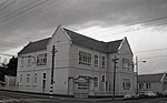
Kaikorai Valley College is a large co-educational secondary school in Dunedin, New Zealand. Initially starting as Kaikorai Valley High School in 1958, the school combined with Kenmure Intermediate School in 1996 to become Kaikorai Valley College,. It celebrated its 50th jubilee in 2008. The college has approximately 65 international students, and has sister school relationships with Sakuragaoka High School, Kun-ei Girls High School and Myojo Gakuen in Japan; Po Leung Kuk Ngan Po Ling College in Hong Kong; and Harbin Number 13 Middle School in China.Facilities include its own theatre and dance studio. The college had continual improvements to facilities with new computer suites, well equipped science laboratories, a new full sized gymnasium and open plan design and technology areas. Furthermore, the brand new administration block was opened by John Key in 2012. The school also has a disabled and special needs unit. The school has its own radio show on Otago Access Radio. Pupils of Kaikorai Valley College use the adjacent Kaikorai Stream for outdoor education, studying water quality and flow, learning fly fishing and monitoring waste water.

Excerpt from the Wikipedia article Kaikorai Valley College (License: CC BY-SA 3.0, Authors, Images).

Kaikorai Valley College
Kaikorai Valley Road, Dunedin Kenmure

Geographical coordinates (GPS) Address Phone number Website External links Nearby Places
placeShow on map

Wikipedia: Kaikorai Valley CollegeContinue reading on Wikipedia

Geographical coordinates (GPS)

Latitude Longitude
N -45.88206 ° E 170.466995 °
placeShow on map

Address

Kaikorai Valley College

Kaikorai Valley Road 500
9011 Dunedin, Kenmure
Otago, New Zealand
mapOpen on Google Maps

Phone number

call+6434536035

Website
kvc.school.nz

linkVisit website

linkWikiData (Q15232536)
linkOpenStreetMap (207532512)

Year 10 Kaikorai Valley College students measuring the cross sectional area of a transect across the stream to determine, with velocity data, the flow rate.
Share experience

Nearby Places

Mornington, Dunedin
Mornington, Dunedin

Mornington is a suburb of the city of Dunedin, in the South Island of New Zealand. It is situated on hilly slopes 2 kilometres (1.2 mi) to the west of the city centre, the slopes forming part of a ridge which surrounds the heart of the city. According to the 2013 New Zealand census, Mornington has a population of 3,267, a decrease of 126 people since the 2006 census. There were 1,518 males and 1,749 females.The use of the name Mornington for the area was first recorded in 1862. There seems to be some conjecture about the origin of the name – some sources record it as being purely descriptive, with the suburb receiving the first rays of the sunrise. There is some likelihood, however, that it was named by early landholder David Mailer after Mornington, Victoria. Mornington was a separate borough until amalgamation with Dunedin city in 1916Mornington's main streets are Mailer Street, Elgin Road, Glenpark Avenue, Eglinton Road, and Kenmure Road. It is a mainly residential suburb, with a retail area on Mailer Street. The suburb is surrounded by the suburbs of Kenmure to the west, Roslyn to the north, Maryhill to the southwest, Belleknowes to the northeast, and The Glen – divided roughly between Mornington and Caversham in the southeast. To the east lies the City Rise, an area that includes some old grand houses which surround the southern end of the city centre. The Town Belt, a bush-clad green belt dating to the early years of Dunedin's settlement, follows the slopes of the ridge, and lies immediately below Mornington, most prominently to the northeast. Mornington is the home to several sports grounds and teams, and was the site of New Zealand's first golf course, opened in 1872. The Zingari-Richmond Rugby Club is based at Montecillo ground in Eglinton Road. Montecillo, the city's home for war veterans, was moved from Eglinton Road to South Dunedin in the 1990s. Immediately above Montecillo ground is Unity Park, which is a venue for Mornington Football (soccer) club. Unity Park affords panoramic views across the central city, and is the site of a statue of Antarctic explorer Admiral Richard Byrd, commemorating the 1928 departure for the southern continent from Dunedin by Byrd's 1928 expeditionLandmarks within Mornington include the suburb's former post office in Mailer Street, a distinctive building completed in 1905 with small a mock-Byzantine domed tower above the entrance.

Maryhill, New Zealand

Maryhill is a residential suburb of the New Zealand city of Dunedin. It is located on a ridge to the southwest of the central city between the suburbs of Mornington, Kenmure, and Caversham. The smaller suburb of Balaclava lies immediately to its west. Maryhill is believed to take its name from a district in the city of Glasgow in Scotland, where many of the early settlers of the suburb originated. In this regard it is unusual among Dunedin suburbs, many of which are named for suburbs of Edinburgh - Maryhill and the nearby Little Paisley are the only suburbs named for Glaswegian locations, and the latter is an old name rarely used today. A second theory is that Maryhill was named in honour of Mary, the wife of early Dunedin settler John Bathgate.The main road in Maryhill is Glenpark Avenue, which runs south from a series of small streets which connect it with Mailer Street Mornington. At its southern end, it links with a tortuous zig-zag road, Lancefield Street, which leads to the suburb of Caversham. Several roads cross Glenpark Avenue; notable among them are Maryhill Terrace and Glen Road. These connect with Caversham at The Glen, in Maryhill's southwestern corner. Elgin Road, which runs parallel with Glenpark Avenue and lies at roughly the border of Maryhill, Mornington, and Kenmure, forms a major access road at Maryhill's western edge. This route links with Mailer Street and Kenmure Road at its northernmost point, and with Mornington Road at its southern end. Little Paisley is an old name for an area close to the boundary of Maryhill and Mornington, between the top of Glen Road and Eglinton Road close to Dunedin Southern Cemetery. It gained this name in the early years of Dunedin's settlement, was settled by weavers from Paisley. The name is rarely used today. Maryhill was connected from 1855 to 1955 to the Dunedin cable tramway system via the Maryhill Extension. The line, which followed Glenpark Avenue from Mornington, was perfectly straight, and was sometimes referred to as The Big Dipper because of its undulating course. Maryhill's notable residents have included writer and publisher Sir Alfred Hamish Reed.

Brockville, New Zealand

Brockville is a residential suburb of the New Zealand city of Dunedin. It is located at the edge of the city's main urban area, 5.5 kilometres (3.4 mi) to the northwest of the city centre, but separated from it by both a ridge of hills and the Kaikorai Valley. The name Brockville comes from early English settler Frederick Brock-Hollinshead, who, after arriving in Dunedin in 1853, began to build a substantial residence in this location. Brock-Hollinshead abandoned the house before completing it, and returned to England.The suburb's main street is Brockville Road, which leaves Kaikorai Valley Road close to the boundary between the suburbs of Kaikorai and Bradford, winding up the slopes which forms the northwestern boundary of Kaikorai Valley. Frasers Creek winds around the edge of this slope. The scenic reserve of Fraser's Gully, through which this stream flows, lies immediately to the northeast of Brockville, between it and the suburb of Halfway Bush, ending on Frasers Road off Kaikorai Valley Road. The main residential area of Brockville is centred on the upper section of Brockville Road, and the numerous crescents which branch off it. The suburb contains a kindergarten and a Brockville Full Primary School, which are located on this part of Brockville Road. The lower part of Brockville Road is occasionally regarded as a separate suburb known as Glenross, including the newly built houses on Sretlaw Place. Brockville Road terminates at a junction with Dalziel Road, a semi-rural road which marks the edge of Dunedin's main urban area. This road links with Three Mile Hill Road above Halfway Bush in the north, running past the city's Mount Grand Reservoir before joining with another road leading down to the suburb of Burnside. A dry weather road links the southern end of Dalziel Road with Abbotsford.Brockville possesses a church, corner shop, takeaway shop and a convent rest home. In addition to all these, Brockville has two residential parks, Brockville football and cricket grounds and skate ramp, and a community park and playground situated to the north of a small cluster of shops on Brockville Road.

Calton Hill, New Zealand

Calton Hill is an elevated southern residential suburb of the City of Dunedin in New Zealand's South Island. The suburb is named after Calton Hill in Edinburgh, Scotland, and some of its street names carry similar etymological roots. The suburb was established in the 1900s, as part of the second wave of suburban development in Dunedin. The parent suburb is Caversham, one of Dunedin's (and New Zealand's) oldest suburbs, established two generations prior as part of the first wave of settlement of the area. During the first wave of settlement before Calton Hill was established, it is unclear what modern day Calton Hill was called; possibilities include Caversham Hills or, more informally, John Sidey's farm. Calton Hill is the geographical area bounded by the Dunedin Southern Motorway to the north and the Caversham Valley Forest Reserve beyond; farmland in the south and west that borders Concord and the Burnside industrial area; and an arbitrary eastern border of Corstorphine Road, Sidey Street, Cole Street and South Road (where it terminates near the Dunedin Southern Motorway). The South Island Main Trunk railway and the motorway (part of State Highway 1) further distinguish its northern border. For many of those on the northern and eastern slopes, Calton Hill has views to Mt Cargill (Kapukataumahaka) and Flagstaff (Te Whanaupaki) in the north and the Pacific Ocean in the south-east. To the east, Calton Hill looks over the central plains of Dunedin city with Signal Hill (Te Pahuri o te Rangipohika), the Otago Harbour and Otago Peninsula in the distance. For those on the western slopes, the Kaikorai Valley and Green Island are in immediate view with Saddle Hill and the Taieri Plains beyond.