place

Dunedin Southern Cemetery

Cemeteries in DunedinHeritage New Zealand Category 1 historic places in OtagoJewish New Zealand historyJewish cemeteries
William Cargill gravestone

The Southern Cemetery in the New Zealand city of Dunedin was the first major cemetery to be opened in the city. The cemetery was opened in 1858, ten years after the founding of the city in an area known as Little Paisley. This area lies at the southern end of Princes Street, one of the city's main streets, close to the suburbs of Kensington, Maryhill, and The Glen (part of Caversham).

Excerpt from the Wikipedia article Dunedin Southern Cemetery (License: CC BY-SA 3.0, Authors, Images).

Dunedin Southern Cemetery
South Road, Dunedin Kensington

Geographical coordinates (GPS) Address Nearby Places
placeShow on map

Wikipedia: Dunedin Southern CemeteryContinue reading on Wikipedia

Geographical coordinates (GPS)

Latitude Longitude
N -45.8899 ° E 170.4937 °
placeShow on map

Address

South Rd, Cemetery

South Road
9016 Dunedin, Kensington
Otago, New Zealand
mapOpen on Google Maps

William Cargill gravestone
Share experience

Nearby Places

Kensington, Dunedin
Kensington, Dunedin

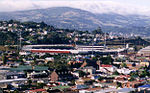
Kensington is a small suburb of the New Zealand city of Dunedin, nestled to the south of a hilly spur between the central city and the major suburb of South Dunedin, some 2.4 kilometres (1.5 mi) to the south of the city centre. The suburb was named for the leafy London suburb, possibly by John Hyde Harris, who subdivided the area in the 1860s.Kensington is located on and around King Edward Street, close to the point at which it becomes Princes Street. This is one of Dunedin's main arterial routes, with King Edward Street stretching south to become the main road through South Dunedin, and Princes Street heading north to Dunedin's city centre. The suburb lies at the foot of a spur off Maryhill officially referred to as Montecillo Ridge, and close to the inner city sports ground, the Oval. This 9.3-hectare (23-acre) ground, originally called the Southern Recreation Ground, is now referred to as the Kensington Oval, so as to distinguish it from the University Oval in the north of the city. This ground is actually triangular, but at one time contained a separate oval cricket ground, which gave it its name. Dunedin Southern Cemetery sits on the slope of Montecillo Ridge immediately above Kensington, separated from it by South Road, a main route to Caversham, which joins with Princes Street close to the Oval. These two green areas mark the southernmost extreme of Dunedin's Town Belt, which sweeps around the central city in a broad crescent through the suburbs of Mornington, Belleknowes, Roslyn, Maori Hill, Woodhaugh, and Dunedin North. The lower slopes of Montecillo Ridge were at one time the site of "Hillside", the home of Dunedin city's founding father Captain William Cargill. Though the house is long gone, its name lives on in that of South Dunedin's Hillside Road. 
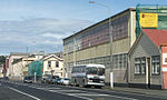
Kensington is largely separated from South Dunedin by an overbridge and railway embankment carrying the South Island Main Trunk railway. The long-closed Kensington railway halt was located immediately to the east of the bridge, and accessed by a flight of stairs in one of the bridge's supports, long since sealed up. A newer flyover 200 metres to the north carries State Highway 1 through Kensington, though there are no slip roads connecting the suburb with the highway. This flyover separates Kensington into two distinct parts, a light industrial zone to the south of the flyover, and a residential zone to the north, at the foot of the ridge. 
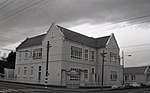
A notable feature of Kensington is the city's army drill hall, located in Bridgman Street immediately to the south of State Highway 1.

Kensington Oval, Dunedin

The Kensington Oval, formerly known as the South Dunedin Recreation Ground, is a park and sports ground in Kensington, Dunedin, New Zealand. It is also known as just The Oval, although this name has become less common in recent years due to the potential confusion with the University Oval in the north of the city.The Kensington Oval is officially regarded as the southern end of the city's Town Belt. The park, which is actually roughly triangular in shape, covers 9.25 hectares (22.9 acres). It is bounded by Princes Street, the northern end of Anderson's Bay Road, and the Dunedin Southern Motorway. Its name dates from 22 March 1864, when it was decided to enclose the main cricket pitch within a formal oval. From that time the former name rapidly fell out of use, and has been rarely used since the beginning of the twentieth century. The first recorded first-class match cricket match was held on the ground in February 1864 when Otago played Canterbury in what was the first ever first-class match to be held in New Zealand. Otago played eight further first-class matches there, the last of which saw them play Canterbury in February 1878. The condition of the playing surface was generally unsatisfactory, with old tree roots protruding from the ground and the pitch unpredictable and at times dangerous to batsmen. In 1879 the Otago Cricket Association requested that the Dunedin City Council make improvements to the ground. When the Council decided not to make improvements, and refused to restrict access to the ground to cricket only, the Association decided to find another venue to play at. The enclosing bounds of the oval were removed in about 1899. Although representative matches are no longer played at the Kensington Oval, it is widely used for club, grade, and social cricket, and has two grass and three artificial wickets, as well as a pavilion. It is also used for softball in summer, and for football and rugby union in winter. The city's Boer War memorial, which stands at the northern corner of the Oval, was designed by Carlo Bergamini and erected in November 1906.

Dunedin Gasworks Museum

Dunedin Gasworks Museum is located in South Dunedin, in the South Island of New Zealand. It is one of only a few known preserved gasworks museums in the world. The main part of the museum is housed in the engine house of the former Dunedin Gasworks in Braemar Street, close to Cargill's Corner, which operated from 1863 until 1987. Other buildings which are included in the museum include the boiler room, boiler house, chimney stack, fitting shop, and blacksmith's shop. The museum includes a unique collection of five stationary steam engines, at least some of which are in working full order. There are also displays of domestic and industrial gas appliances. As well as being an operating museum open to the public, the gasworks museum is also a popular venue for event ranging from music performances to gatherings of steampunk enthusiasts. The Dunedin Gasworks were the first in New Zealand and also the last to cease production. At its peak in the 1970s coal gas was provided to over 18,000 customers in the city. The Edwardian buildings of the gasworks were saved by a trust headed by Elizabeth Hinds, Director of the Otago Settlers Museum, and several are now listed by the New Zealand Historic Places Trust as Category I Historic Places.Much of Dunedin's gasworks facility was pulled down during the 1980s. The idea of restoring the remaining part of the complex into a museum was mooted during the latter part of the decade, with the first work on structural restoration of the buildings beginning in 1989. The museum was opened on 3 February 2001 in a ceremony attended by Dr. George Emerson, Chair of the Dunedin Gasworks Museum Trust, and Sir Neil Cossons, Chairman of English Heritage.

Otago

Otago ( (listen), ; Māori: Ōtākou [ɔːˈtaːkou]) is a region of New Zealand located in the southern half of the South Island administered by the Otago Regional Council. It has an area of approximately 32,000 square kilometres (12,000 sq mi), making it the country's second largest local government region. Its population was 246,000 in June 2022.The name "Otago" is the local southern Māori dialect pronunciation of "Ōtākou", the name of the Māori village near the entrance to Otago Harbour. The exact meaning of the term is disputed, with common translations being "isolated village" and "place of red earth", the latter referring to the reddish-ochre clay which is common in the area around Dunedin. "Otago" is also the old name of the European settlement on the harbour, established by the Weller Brothers in 1831, which lies close to Otakou. The upper harbour later became the focus of the Otago Association, an offshoot of the Free Church of Scotland, notable for its adoption of the principle that ordinary people, not the landowner, should choose the ministers. Major centres include Dunedin (the principal city), Oamaru (made famous by Janet Frame), Balclutha, Alexandra, and the major tourist centres Queenstown and Wānaka. Kaitangata in South Otago is a prominent source of coal. The Waitaki and Clutha rivers provide much of the country's hydroelectric power. Vineyards and wineries have been developed in the Central Otago wine region. Some parts of the area originally covered by Otago Province are now administered by either Canterbury Regional Council or Southland Regional Council.

St. Matthew's Church, Dunedin

St. Matthew's Church is an inner-city Anglican parish church, located on the City Rise in Dunedin, New Zealand. Designed by William Mason (1810-1897) the foundation stone was laid on 11 July 1873 and the building was consecrated on 3 December 1874. It cost 4,874 pounds to construct which wasn't paid off until 1901. It comfortably seated 750 people.A Gothic Revival building, somewhere between the Norman and the Early English style, it is built of bluestone with Port Chalmers breccia for the quoins and facings which is unusual. Very English in its feeling it represents a return to the plain manner of the architect's early career. It is cruciform in plan, with an apsidal chancel where there are five lancet stained glass windows. There are aisles divided from the nave by massive, octagonal piers, a tower and a spire at the south west corner above the principal entrance. There is another entrance at the north west angle. Some in the Diocese wanted the building to become the Cathedral Church but the congregation was unwilling. St. Paul's in the Octagon was designated instead. The church has been fairly closely built around since its construction but retains an attractive appearance. Its internal layout was reversed in the late 20th century but has since been returned to its original orientation. The original pews have been lost but the interior is otherwise little modified. In 1942 the artist Colin McCahon married Anne Hamblett in St Matthew's, the ceremony being performed by her father, the Reverend Hamblett, then the incumbent clergyman. The church has a Category I listing with the New Zealand Historic Places Trust.