place

Seaton, Rutland

Civil parishes in RutlandRutland geography stubsVillages in Rutland
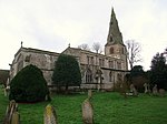
Church of All Hallows, Seaton geograph.org.uk 255733

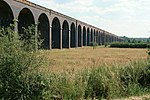
Seaton is a village and civil parish in the county of Rutland in the East Midlands of England. The population of the civil parish was 178 at the 2001 census, including Stoke Dry and Thorpe by Water, increasing to 250 at the 2011 census. Nearby is the large Seaton Viaduct, on the Oakham to Kettering railway line. It is three quarters of a mile long and took four years to build. It has 82 arches which are up to 72 feet (22 m) high. For many years the railway was only used for freight traffic, but a restricted passenger service from Oakham to London via Corby and Kettering was opened in 2010. Seaton railway station, on a different line, closed in 1966. The toponym, first recorded in the Domesday Book as Seieton and Segentone, is of uncertain origin. It probably means the "farm or village of a man named Sǣġa", but it may refer to an otherwise unrecorded stream name Sǣġe, meaning "slow-moving".Thomas Minot, later Archbishop of Dublin, became parson here in 1351.Major-General Robert Overton a prominent soldier and scholar who supported Parliament during the Wars of the Three Kingdoms and served in the New Model Army, died here in 1678, although he was subsequently buried in London.When Henry Royce (founder of Rolls-Royce) was created a baronet, he took Seaton as his territorial designation. His family had worked here as millers. The village has one public house - the George and Dragon, on Main Street. In the east of the parish is Seaton Meadows SSSI.

Excerpt from the Wikipedia article Seaton, Rutland (License: CC BY-SA 3.0, Authors, Images).

Geographical coordinates (GPS)

Latitude Longitude
N 52.572 ° E -0.663 °
placeShow on map

Address


LE15 9HZ , Seaton
England, United Kingdom
mapOpen on Google Maps

Church of All Hallows, Seaton geograph.org.uk 255733
Share experience

Nearby Places

Gretton, Northamptonshire

Gretton is a village and civil parish in North Northamptonshire. It is in Rockingham Forest and overlooks the valley of the River Welland and the neighbouring county of Rutland. At the time of the 2001 census, the parish had a population of 1,240 people, increasing to 1,285 at the 2011 census.The villages name means 'Gravel farm/settlement' or perhaps, 'great farm/settlement'.It is near the town of Corby and the Rockingham Motor Speedway. The village is noted for having the tallest church tower in Northamptonshire, and the second-oldest running pub in Northamptonshire, the Hatton Arms. The Hatton Arms was recently renovated. The pub was originally part of Carlton Manor gatehouse in the 12th century. According to legend it became a pub in 1672 when the licence was granted to a negro servant who saved the life of Sir Christopher Hatton, Elizabeth I's chancellor, who lived in nearby Kirby Hall.Gretton is one of the few villages to retain its stocks and whipping post, which can be found on the village green. The last recorded use was in 1858, when a villager was put in the stocks for six hours after failing to pay a fine for drunkenness.Iron currency bars from the Iron Age have been found. The Roman colonists also worked the ironstone deposits in this area. There were ironworks here in Edward the Confessor's reign in the 11th century, when Gretton was a royal manor. The industry came to the fore again from 1881 to 1980, providing ore for Corby's steel works.Notable people living in Gretton include ultra marathon runner and yeast expert Jim Wynn and marathon runner and primary school teacher Sarah Wynn. Jim and Sarah Wynn started Gretton's notable Turtle Run Club (TRC) in 2019.