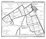
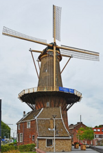
De Roos (literally, "The Rose"), also locally known as Roosmolen or Koren op de Molen, is a wind and platform mill situated within the municipality of Delft, in the South Holland province of the Netherlands.
The mill was originally constructed on the southern city wall of Delft but was later relocated and rebuilt above the western fortifications of the Dutch municipality in 1679. Two principal phases of implementation of the Delft mill followed this reconstruction. The first was dated 1728, while the second was from the 1760s. The building has been the subject of multiple restoration projects, commencing in the late 1920s and concluding in 2023. The artistic work, whose historical background remains largely uncharted before its 1679 reconstruction, represents the sole surviving mill within the erstwhile fortified zone of Delft, among the eighteen that previously operated within the Dutch city.
On the current site of De Roos, at 111-112 Phoenixstraat, there originally stood a post mill called Gasthuismolen, which was destroyed during a storm in the second half of the 17th century. Previously bordered by the tramway and then the railway line connecting the city to The Hague, the site of De Roos mill has been situated above the Willem of Orange railway tunnel since the second half of the 2010s. The construction of this infrastructure necessitated the hydraulic jacking and the underpinning of the De Roos complex — mill, miller's house, warehouse — and preventive archaeological excavations that revealed remnants of the windmill dating from the late 17th century and early 18th century, as well as elements of the western portion of the medieval city wall of Delft.
Despite periods of inactivity, particularly during periods of restoration and repair, the mill remains operational. It has been managed by many millers, including those from the Kouwenhoven, van Rhijn, and De Vreede families.
On June 29, 1967, the Dutch Cultural Heritage Agency designated the De Roos grain mill, along with the miller's house and warehouse surrounding its skirt, as a national monument. The windmill is conical in shape and of the skirt and platform type. It is rather massive in scope and height, constructed of bricks and jointed stones. The mill is equipped with a rotating cap, and the milling work, which transforms grains of cereals into flour, is powered by a complex set of elements, mostly mechanical, motorized, and electric for a few. The house and warehouse, also constructed of masonry bricks, feature facades with gables.


