place

Woody Bay, Isle of Wight
Bays of the Isle of WightUse British English from June 2015
Woody Bay, IW, UK
Woody Bay, IW, UK

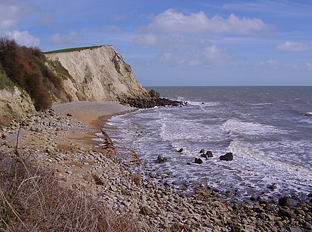
Woody Bay is a small bay on the south coast of the Isle of Wight, England. It lies along the coastline beneath the village of St. Lawrence. The bay faces south towards the English Channel, its shoreline is 260 yards (240 m) in length.The bay has a rocky and exposed shoreline with areas of shingle and a storm beach formed from large pebbles. It is backed by cliffs composed of landslide debris from the Upper Greensand and Chalk. The bay is part of the Undercliff landslide complex, although is a largely stable area of the landslide zone despite recent minor movements. The Isle of Wight Coastal Path runs along the coast behind the bay and onto Woody Point, where the bay can be best viewed from. A small track runs down from the coastal path on which the bay can be accessed. During the winter of 2019/2020 a large rotational landslide took place in the cliff face in the central section of the bay. Further minor landslides took place in the winter of 2020/2021, driving further landslide debris onto the beach. Immediately west of Woody Bay is the Sugarloaf, a geological formation formed from a block of tilted and slipped Upper Greensand Formation originally derived from the inland cliff. A footpath leads to the top of the Sugarloaf, with views along the Undercliff coast.

Excerpt from the Wikipedia article Woody Bay, Isle of Wight (License: CC BY-SA 3.0, Authors, Images).

Woody Bay, Isle of Wight
Woolverton Road,

Geographical coordinates (GPS) Address Nearby Places
placeShow on map

Wikipedia: Woody Bay, Isle of WightContinue reading on Wikipedia

Geographical coordinates (GPS)

Latitude Longitude
N 50.58171 ° E -1.24648 °
placeShow on map

Address

Woolverton Road
PO38 1XW
England, United Kingdom
mapOpen on Google Maps

Woody Bay, IW, UK
Woody Bay, IW, UK
Share experience

Nearby Places

Whitwell, Isle of Wight

Whitwell is a small village and former civil parish, now in the parish of Niton and Whitwell, on the south of the Isle of Wight, England, approximately 5 kilometres north-west of Ventnor, the village's nearest town. In addition to this, it is about five minutes away from its neighbouring small villages of Godshill and Niton. According to 2001 census data, the total population of the village was 578. There is a variety of stone and thatched housing, as well as some more modern housing, the most recent of which was completed in 2006. Whitwell's small size has led it to become a very close-knit community with a range of amenities including a garage, a 700-year-old church, the oldest pub on the island, dating back from the 15th century and a post office, which was recently re-located to a new premises inside the church bell tower. A trout farm is located towards Nettlecombe, with three lakes covering 1.5 acres (0.61 ha). The waters are well stocked with carp, roach and tench.Whitwell is named after the "White Well" inside the village. The well was visited by many during medieval times on pilgrimages, and now well dressing occurs annually each summer. Across Whitwell, six more old water standards can be seen. They were built in 1887 by William Spindler. Half the cost of installing the wells was covered by William Spindler himself, the remainder by people of the village. The water was supplied by Mr Granville Ward from a spring on his land at Bierley.