St Lawrence, Isle of Wight

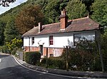
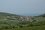
St Lawrence is a village and former civil parish, now in the parish of Ventnor, on the south (English Channel) coast of the Isle of Wight, in southern England. It is located to the west of the town of Ventnor, in the Undercliff, which is subject to landslips. The Undercliff lies between the original high cliff and the sea, formed over thousands of years, since the last Ice Age, from accumulated landslips. Several rocky coves can be accessed from the coastal path, which affords fine views of some prominent Victorian villas, set in a wooded landscape below the great rock wall of the original sea cliff: Woody Bay, Mount Bay and Orchard Bay. The area of the parish was around 329 acres (133 ha) in size. In 1931 the parish had a population of 329. On 1 April 1933 the parish was abolished and merged with Ventnor.
Excerpt from the Wikipedia article St Lawrence, Isle of Wight (License: CC BY-SA 3.0, Authors, Images).St Lawrence, Isle of Wight
Undercliff Drive,
Geographical coordinates (GPS) Address Nearby Places Show on map
Geographical coordinates (GPS)
| Latitude | Longitude |
|---|---|
| N 50.588611111111 ° | E -1.2397222222222 ° |
Address
Undercliff Drive
PO38 1UJ , Lowtherville
England, United Kingdom
Open on Google Maps


