Nettlecombe, Isle of Wight
Isle of Wight geography stubsVillages on the Isle of Wight

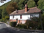
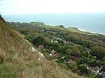
Nettlecombe is a farming hamlet on the Isle of Wight. It is the site of a deserted medieval village and there is evidence of earthworks close to the present hamlet. There are several fishing lakes in Nettlecombe.It lies along Nettlecombe Lane, about half a mile north-east of Whitwell. Until 1952, the Isle of Wight Central Railway had a station on Nettlecombe Lane.
Excerpt from the Wikipedia article Nettlecombe, Isle of Wight (License: CC BY-SA 3.0, Authors, Images).Nettlecombe, Isle of Wight
Nettlecombe Lane,
Geographical coordinates (GPS) Address Nearby Places Show on map
Geographical coordinates (GPS)
| Latitude | Longitude |
|---|---|
| N 50.602 ° | E -1.258 ° |
Address
Nettlecombe Lane
Nettlecombe Lane
PO38 2AD , Niton and Whitwell
England, United Kingdom
Open on Google Maps


