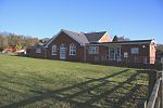
Clopton, Suffolk

Clopton is a village and civil parish in Suffolk. It is located between Ipswich and Debenham two kilometres north of Grundisburgh on the River Lark. The village is no larger than a series of houses either side of the B1078, surrounded by farm land. The village itself has no clear centre; houses and other buildings are concentrated around the four manors of Kingshall, Brendhall, Rousehall and Wascolies, all of which are mentioned in the Domesday Book of 1086.As of 2011, the population of the parish numbered 375 people. The village previously had a school, which was built in 1875 and had capacity for 100 pupils with an average attendance of 56, however it closed in the late 1930s. Pupils instead attend schools in Grundisburgh or Woodbridge, with a bus service provided by Suffolk County Council.
Excerpt from the Wikipedia article Clopton, Suffolk (License: CC BY-SA 3.0, Authors, Images).Clopton, Suffolk
B1079, East Suffolk
Geographical coordinates (GPS) Address Nearby Places Show on map
Geographical coordinates (GPS)
| Latitude | Longitude |
|---|---|
| N 52.117 ° | E 1.25 ° |
Address
B1079
IP13 6QA East Suffolk
England, United Kingdom
Open on Google Maps


