place

Granite, Virginia

Geography of Chesterfield County, VirginiaGeography of Richmond, Virginia
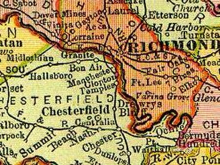
Va 1895 granite
Va 1895 granite

Granite was an unincorporated community in Chesterfield County, Virginia. It was originally located along the Richmond and Danville Railroad five miles west of Manchester and about a mile south of the rapids of the James River along Powhite Creek. Most of the Granite area of Chesterfield County was annexed by the independent city of Richmond on January 1, 1970.

Excerpt from the Wikipedia article Granite, Virginia (License: CC BY-SA 3.0, Authors, Images).

Granite, Virginia
Forest Hill Avenue, Richmond

Geographical coordinates (GPS) Address Nearby Places
placeShow on map

Wikipedia: Granite, VirginiaContinue reading on Wikipedia

Geographical coordinates (GPS)

Latitude Longitude
N 37.533055555556 ° E -77.507222222222 °
placeShow on map

Address

Forest Hill Avenue 6038
23225 Richmond
Virginia, United States
mapOpen on Google Maps

Va 1895 granite
Va 1895 granite
Share experience

Nearby Places

Agecroft Hall
Agecroft Hall

Agecroft Hall is a Tudor manor house and estate located at 4305 Sulgrave Road on the James River in the Windsor Farms neighborhood of Richmond, Virginia, United States. The manor house was built in the late 15th century, and was originally located in the Irwell Valley at Agecroft, Pendlebury, then in the historic county of Lancashire, England, but by the 20th century it was unoccupied and in a state of disrepair. Mr. Thomas C. Williams, Jr. of Richmond, Virginia, a wealthy entrepreneur, purchased Agecroft Hall upon the advice of his architect, Henry G. Morse. During the Country Place Era, when many wealthy American families were building extensive country estates emulating those they had seen in Europe, Mr. Williams, whose business interests included tobacco, banking and shipping wished to build a true English manor house on his 23-acre estate overlooking the James River. The manor house was dismantled, crated, transported across the Atlantic, and reconstructed in Richmond's Windsor Farms neighborhood - then a fashionable new neighborhood being developed by Mr. Williams on the Williams' family farm site, which had long been known as 'Windsor.' The architect, Mr. Morse, was retained to oversee the reconstruction. The intention was not to replicate Agecroft as it had stood in Lancashire, but rather to create a functional and comfortable mansion reminiscent of its English predecessor. The original floor plan was abandoned and many 20th century conveniences were included. Reconstruction took two years and cost approximately $250,000, a considerable sum for that time. The project was completed during the spring of 1928. The following year Mr. Williams died, having stipulated in his will that upon his widow's death or relocation, Agecroft Hall would become a house museum.

Boulevard Bridge
Boulevard Bridge

Boulevard Bridge in the independent city of Richmond, Virginia is a toll bridge which carries State Route 161 across the James River. At 2,030 feet (620 m) long, the Boulevard Bridge was completed in 1925. It was privately owned and financed by the Boulevard Bridge Corporation for the purpose of providing access to the new Westover Hills neighborhood in South Richmond, where one of the selling points of the homes was free bridge access. It is named for The Boulevard, a main route through Richmond that ends just north of the bridge in Byrd Park. For many years, 5-cent tolls were collected at a toll booth midway on the span, and it became widely known as the "Nickel Bridge". Some years later, tolls were increased to 10 cents, and the nickname became the "Dime Bridge". However, despite all subsequent toll increases, it is still known today as the "nickel bridge" to many locals.Initially, the early toll-barrier was located in the middle of the span (actually above the north shore of the river between the canal and the north end), because all the property on either side except the right-of-way for the roadway itself was owned by others, and the toll barrier at that location could be erected at no additional land acquisition expense. It was certainly not possible to circumvent paying the toll at that location. The toll booths were relocated to a plaza north of the bridge in the mid-1960s. During the years of ownership by the Boulevard Bridge Corporation, Westover Hills residents were given free access across the bridge by the use of a special license plate that was attached below the state plates on their cars. These plates had to be applied for and were also sold to the general public. They were changed each year, and in the last years before Richmond Metropolitan Authority (RMA) control, windshield stickers were used. On November 24, 1969, the RMA, which was building Richmond's new expressway system at the time, purchased the Boulevard Bridge for $1.2 million. The toll on the bridge was kept at 10 cents until 1988, when it was doubled to 20 cents.In August 1992, the RMA closed the bridge for 18 months to complete extensive renovation work, which included widening the existing lanes, installing new toll booths and equipment on the north end of the bridge, and improving safe access for bicycles and pedestrians. The bridge reopened in October 1993. The toll was increased again in 1998 to 25 cents. In 2008, the RMA increased the tolls on all of its roads, bringing the Boulevard Bridge to the rate of 35 cents. As of September 1st, 2023, the current toll rate is 50 cents. Despite the renovation work in the early 1990s, weight restrictions on the bridge limit vehicles to under 7,500 lbs.