place

Broad Bay, New Zealand

Bays of OtagoOtago PeninsulaPopulated places in OtagoSuburbs of DunedinUse New Zealand English from January 2022
Fletcher House Broad Bay2

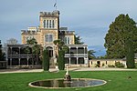
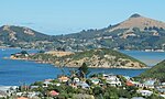
The settlement of Broad Bay (Māori: Whaka Oho Rahi) is located on the Otago Harbour coast of Otago Peninsula, in the South Island of New Zealand. It is administered as part of the city of Dunedin, and is technically a suburb of that city, though its isolation and semi-rural nature make it appear as a settlement in its own right. Broad Bay is 13 kilometres (8.1 mi) to the east of the city centre, but due to the shape of the peninsula's coastline, the heart of the city cannot be seen from Broad Bay. A large bluff, Grassy Point, lies between Broad Bay and the harbourside settlements of Company Bay and Macandrew Bay to the west. The bluff is skirted by Portobello Road, the road which winds around the southeastern shore of the harbour between inner Dunedin and Portobello, 2 kilometres (1.2 mi) to the northeast of Broad Bay, and by the Otago Harbour Cycleway, which runs alongside it. The Camp Road walking track connects Broad Bay with Larnach Castle, close to the ridge of the peninsula. Broad Bay is situated on the shore of an aptly named wide bay (Broad Bay) and a smaller bay to the north east (Turnbulls Bay); between these lie a short peninsula (on which is sited the settlement's small historic cemetery), which terminates in the steep, finger-like headland of Yellowhead. The distinctive peak of Harbour Cone forms a backdrop to the settlement as seen from the harbour. The settlement is home to the heritage-listed Fletcher House, constructed in 1909 and restored in 1992, the first house by Fletcher Construction founder Sir James Fletcher. Like several settlements on the peninsula - including Portobello and Macandrew Bay, which lies 3 kilometres (1.9 mi) to the southwest - Broad Bay is a commuter settlement and a haven for alternative lifestylers. These settlements have a strong arts community, with many of their residents connected in some way with the visual or performing arts.

Excerpt from the Wikipedia article Broad Bay, New Zealand (License: CC BY-SA 3.0, Authors, Images).

Broad Bay, New Zealand
Waikana Street, Dunedin Broad Bay

Geographical coordinates (GPS) Address Nearby Places
placeShow on map

Wikipedia: Broad Bay, New ZealandContinue reading on Wikipedia

Geographical coordinates (GPS)

Latitude Longitude
N -45.85 ° E 170.62083333333 °
placeShow on map

Address

Waikana Street 8
9014 Dunedin, Broad Bay
Otago, New Zealand
mapOpen on Google Maps

Fletcher House Broad Bay2
Share experience

Nearby Places

Macandrew Bay
Macandrew Bay

Macandrew Bay (Māori: Te Roto Pāteke) is located on the Otago Peninsula in the South Island of New Zealand. It is situated on the edge of Otago Harbour, and is named for pioneer Scottish settler James Macandrew who lived here during his later life. The Te Reo Māori name for the bay, Te Roto Pāteke, refers to the Brown teal (Māori: Pāteke) formerly prevalent in the area. Early European residents of the area called the bay "The Hundreds", due to the large number of boulders which covered the foreshore.Macandrew Bay is a suburb of Dunedin, but has the feel of an isolated coastal settlement and is often regarded as a separate township, even though the heart of the city is visible 10 kilometres away at the head of the harbour. It is both a commuter and a harbourside retreat from the city. The settlement centres on an area around the junction of Portobello Road and Greenacres Street, the latter a narrow road which rises steeply towards the interior of the Peninsula. Greenacres Street roughly follows the valley of the small Rodgers Creek. The community hall lies on the lower part of Greenacres Street close to its junction with Portobello Road, and the settlement's few shops lie immediately to the southwest of the junction. Behind these shops lie the community's primary school and cemetery, the latter of which includes the grave of James Macandrew. The bay has a small beach opposite the shops, which is well-used by the public. The beach was created artificially, with sand brought to the bay from the nearby Pacific coast. The area around the beach has been turned into a small public park, and landscaping of this was completed in 1979.Macandrew Bay is the largest of several settlements which lie on the harbour coast of Otago Peninsula. Between it and Dunedin lies Glenfalloch, a private gardens open to the public. Beyond Macandrew Bay to the northeast lie Company Bay and Raynbirds Bay and to the southwest is Colinswood, the latter named for James Macandrew's house. These small settlements could be considered "suburbs" of Macandrew Bay. Beyond Raynbirds Bay lie Broad Bay and Portobello. These settlements are connected to each other and to Dunedin's city centre by Portobello Road, a winding road which runs along the harbour coast of the peninsula, and by the Otago Harbour Cycleway, which runs alongside it Both the road and the sea wall which lies along the harbour edge were constructed by prison labour in the 1860s.A second route, Castlewood Road, rises from Company Bay to meet with Highcliff Road, which runs along the ridge of the peninsula from Dunedin to Portobello. Castlewood Road also connects with Camp Road, which lead to the stately home Larnach Castle, situated above Broad Bay.