Otago Harbour
Calderas of New ZealandExtinct volcanoesGeography of DunedinGeography of OtagoIncomplete lists from November 2018 ... and 8 more
Landforms of OtagoMiocene volcanoesOtago PeninsulaPolygenetic shield volcanoesPorts and harbours of New ZealandShield volcanoes of New ZealandSubmarine calderasUse New Zealand English from November 2018

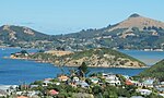
Otago Harbour is the natural harbour of Dunedin, New Zealand, consisting of a long, much-indented stretch of generally navigable water separating the Otago Peninsula from the mainland. They join at its southwest end, 21 km (13 mi) from the harbour mouth. It is home to Dunedin's two port facilities, Port Chalmers (half way along the harbour) and at Dunedin's wharf (at the harbour's end). The harbour has been of significant economic importance for approximately 700 years, as a sheltered harbour and fishery, then deep water port.
Excerpt from the Wikipedia article Otago Harbour (License: CC BY-SA 3.0, Authors, Images).Otago Harbour
Hatchery Road,
Geographical coordinates (GPS) Address Nearby Places Show on map
 Continue reading on Wikipedia
 Geographical coordinates (GPS)
| Latitude | Longitude |
|---|---|
| N -45.8317 ° | E 170.6294 ° |
Address
Hatchery Road 3
9023 , Portobello
Otago, New Zealand
Open on Google Maps