place

Company Bay

Suburbs of DunedinUse New Zealand English from January 2022
Macandrew Bay and Otago Harbour (aerial view)

Company Bay is a semi-residential suburb of Dunedin, New Zealand, located on the Otago Peninsula between Macandrew Bay and Broad Bay. Access to surrounding suburbs and the centre of the city is via Portobello Road, which skirts the edge of Otago Harbour. A smaller, winding road ascends from the bay, linking with the peninsula's ridge road (Highcliff Road) close to Larnach Castle at Pukehiki.

Excerpt from the Wikipedia article Company Bay (License: CC BY-SA 3.0, Authors, Images).

Company Bay
Castlewood Road, Dunedin Company Bay

Geographical coordinates (GPS) Address Nearby Places
placeShow on map

Wikipedia: Company BayContinue reading on Wikipedia

Geographical coordinates (GPS)

Latitude Longitude
N -45.858 ° E 170.601 °
placeShow on map

Address

Castlewood Road

Castlewood Road
9014 Dunedin, Company Bay
Otago, New Zealand
mapOpen on Google Maps

Macandrew Bay and Otago Harbour (aerial view)
Share experience

Nearby Places

Macandrew Bay
Macandrew Bay

Macandrew Bay (Māori: Te Roto Pāteke) is located on the Otago Peninsula in the South Island of New Zealand. It is situated on the edge of Otago Harbour, and is named for pioneer Scottish settler James Macandrew who lived here during his later life. The Te Reo Māori name for the bay, Te Roto Pāteke, refers to the Brown teal (Māori: Pāteke) formerly prevalent in the area. Early European residents of the area called the bay "The Hundreds", due to the large number of boulders which covered the foreshore.Macandrew Bay is a suburb of Dunedin, but has the feel of an isolated coastal settlement and is often regarded as a separate township, even though the heart of the city is visible 10 kilometres away at the head of the harbour. It is both a commuter and a harbourside retreat from the city. The settlement centres on an area around the junction of Portobello Road and Greenacres Street, the latter a narrow road which rises steeply towards the interior of the Peninsula. Greenacres Street roughly follows the valley of the small Rodgers Creek. The community hall lies on the lower part of Greenacres Street close to its junction with Portobello Road, and the settlement's few shops lie immediately to the southwest of the junction. Behind these shops lie the community's primary school and cemetery, the latter of which includes the grave of James Macandrew. 
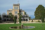
The bay has a small beach opposite the shops, which is well-used by the public. The beach was created artificially, with sand brought to the bay from the nearby Pacific coast. The area around the beach has been turned into a small public park, and landscaping of this was completed in 1979.Macandrew Bay is the largest of several settlements which lie on the harbour coast of Otago Peninsula. Between it and Dunedin lies Glenfalloch, a private gardens open to the public. Beyond Macandrew Bay to the northeast lie Company Bay and Raynbirds Bay and to the southwest is Colinswood, the latter named for James Macandrew's house. These small settlements could be considered "suburbs" of Macandrew Bay. Beyond Raynbirds Bay lie Broad Bay and Portobello. These settlements are connected to each other and to Dunedin's city centre by Portobello Road, a winding road which runs along the harbour coast of the peninsula, and by the Otago Harbour Cycleway, which runs alongside it Both the road and the sea wall which lies along the harbour edge were constructed by prison labour in the 1860s.A second route, Castlewood Road, rises from Company Bay to meet with Highcliff Road, which runs along the ridge of the peninsula from Dunedin to Portobello. Castlewood Road also connects with Camp Road, which lead to the stately home Larnach Castle, situated above Broad Bay.

Broad Bay, New Zealand

The settlement of Broad Bay (Māori: Whaka Oho Rahi) is located on the Otago Harbour coast of Otago Peninsula, in the South Island of New Zealand. It is administered as part of the city of Dunedin, and is technically a suburb of that city, though its isolation and semi-rural nature make it appear as a settlement in its own right. Broad Bay is 13 kilometres (8.1 mi) to the east of the city centre, but due to the shape of the peninsula's coastline, the heart of the city cannot be seen from Broad Bay. A large bluff, Grassy Point, lies between Broad Bay and the harbourside settlements of Company Bay and Macandrew Bay to the west. The bluff is skirted by Portobello Road, the road which winds around the southeastern shore of the harbour between inner Dunedin and Portobello, 2 kilometres (1.2 mi) to the northeast of Broad Bay, and by the Otago Harbour Cycleway, which runs alongside it. The Camp Road walking track connects Broad Bay with Larnach Castle, close to the ridge of the peninsula. Broad Bay is situated on the shore of an aptly named wide bay (Broad Bay) and a smaller bay to the north east (Turnbulls Bay); between these lie a short peninsula (on which is sited the settlement's small historic cemetery), which terminates in the steep, finger-like headland of Yellowhead. The distinctive peak of Harbour Cone forms a backdrop to the settlement as seen from the harbour. The settlement is home to the heritage-listed Fletcher House, constructed in 1909 and restored in 1992, the first house by Fletcher Construction founder Sir James Fletcher. Like several settlements on the peninsula - including Portobello and Macandrew Bay, which lies 3 kilometres (1.9 mi) to the southwest - Broad Bay is a commuter settlement and a haven for alternative lifestylers. These settlements have a strong arts community, with many of their residents connected in some way with the visual or performing arts.

Glenfalloch Gardens

Glenfalloch is a private garden and restaurant near Macandrew Bay on Otago Peninsula, New Zealand. The gardens are owned and run by the Otago Peninsula Trust.Glenfalloch was established in 1871 by George Gray Russell, who bought the land from pioneer settler James Macandrew. It covers 12.1 hectares (30 acres). Russell, a businessman who helped found the National Mortgage & Agency Co Ltd (now part of Fletcher Challenge), set out the gardens and lived at Glenfalloch until 1900. Phillip Barling purchased Glenfalloch in 1917, and the gardens were opened to the public by his son in 1956. The Otago Peninsula Trust purchased the property in the late 1960s.Glenfalloch's name is Gaelic, and means "hidden valley". The heart of the gardens is a woodland area with native trees dating back prior to the garden's establishment, including one matai estimated to be 1000 years old, as well as many exotic species planted in the late 19th century by the gardens' first owner. The small Russell Creek runs through the gardens down to an open lawn area around the restaurant and homestead. Many flower species are found in the gardens, with rhododendrons, azaleas, roses, magnolias, and fuchsias dominating. The Homestead is registered as a Category II historic place by Heritage New Zealand.Glenfalloch is regularly involved in and host of cultural events, including an annual spring festival of art and regular poetry readings. An arts residency aimed at potters and ceramicists is also run by the Otago Peninsula Trust, with the gardens' potters studio and cottage available to the recipient.

St Leonards, Dunedin

St Leonards is a suburb of the New Zealand city of Dunedin. It is located close to the northern shore of the Otago Harbour and on the hilly slopes above the harbour. St Leonards is 8.5 kilometres (5.3 mi) northeast of Dunedin's city centre, between the small settlement of Burkes and Sawyers Bay. St Leonards was named by early settler David Carey for the birthplace of his wife, the English town of St Leonards-on-Sea, on the Sussex coast.Rail and road links between central Dunedin and Port Chalmers run alongside St Leonards on the narrow strip of land between the hill slopes and harbour. The suburb is separate from the contiguous urban area of Dunedin. The suburb is residential, and contains a significant number of smaller homes. The area is a popular residence for students from the University of Otago, and is also popular with alternative lifestylers. The suburb consists mainly of two roughly parallel roads, the Dunedin-Port Chalmers highway (State Highway 88), which runs close to the harbour, and St Leonards Drive, the former main route to Port Chalmers, which winds around the lower slopes of the hills on which St Leonards sits. The Port Chalmers Branch railway line runs parallel with the highway next to the harbour's edge. In 2012, the Dunedin Harbour Cycleway was extended to reach St Leonards.The suburbs of St Leonards, Maia, Burkes, and Ravensbourne, are often collectively referred to as West Harbour. Under this name, the area was a separate borough for many years from 1877 until amalgamation with the city of Dunedin in 1963.

Sawyers Bay
Sawyers Bay

Sawyers Bay is a suburb of the New Zealand city of Dunedin. It is located 1.5 kilometres (0.93 mi) to the southwest of Port Chalmers in a wide valley on the shore of Mussel Bay, 13 kilometres (8.1 mi) to the northeast of Dunedin city centre. The suburb, on the western shore of Otago Harbour, lies between the two rocky headlands of Port Chalmers in the east and Roseneath in the west. The South Island Main Trunk rail line and State Highway 88 run along the shore of the bay. The name of the suburb is indicative of the occupation of many of its early settlers; the Sawyers Bay area provided much of the timber used in the early construction industry around both Dunedin and Port Chalmers area. Little remains of Sawyers Bay's early industries; it is now largely a residential suburb. Sawyers Bay's residential area is situated around one long street which runs inland from the bay itself. This street is called Station Road at its coastal end, and Hall Road further inland. At the coastal end, it connects with State Highway 88, the highway which runs along the west coast of Otago Harbour from Port Chalmers to Dunedin via Saint Leonards and Ravensbourne. Inland from here, roads branch off the main road – the most important of these is Stevenson Avenue, which connects with a back road to Port Chalmers (Borlases Road) in the east, and with Upper Junction Road in the west. Upper Junction Road, the winding old road to Port Chalmers from the Dunedin suburb of North East Valley, rises to join with the old Mount Cargill road, which was itself the former main road north out of Dunedin, linking the city's main urban area at Normanby with Waitati. Other notable features of Sawyers Bay include the Port Chalmers Golf Course, located in the north of Sawyers Bay. A bush walk, Grahams Bush, links the end of Hall Road with the Mount Cargill road. Sawyers Bay's most prolific family is the McLachlan clan, whose tenement dates back to pre-European settlement. Its current population base is now comprised by residents reliant on the marine environment and a large contingent of Firefighters