Ruchi (Glarus Alps)
Alpine three-thousandersBreil/BrigelsCanton of Glarus geography stubsGlarus–Graubünden borderGraubünden mountain stubs ... and 4 more
Mountains of GraubündenMountains of SwitzerlandMountains of the AlpsMountains of the canton of Glarus

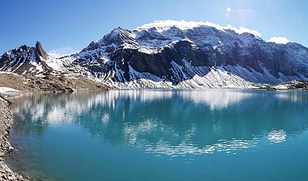
The Ruchi is a mountain in the Glarus Alps, located at an elevation of 3,107 m (10,194 ft) on the border between the Swiss cantons of Glarus and Graubünden. It overlooks the Muttsee (2,446 m or 8,025 ft) on its west side from where a trail leads to the summit. On its south-east side lies a small glacier, the Glatscher da Gavirolas. The Ruchi is connected to the higher summit of the Hausstock on the north-east by a 2 km (1.2 mi) long ridge.The nearest settlements are the villages of Linthal to the north, and Andiast to the south. Administratively, the mountain lies in the municipalities of Glarus Süd and Waltensburg/Vuorz.
Excerpt from the Wikipedia article Ruchi (Glarus Alps) (License: CC BY-SA 3.0, Authors, Images).Ruchi (Glarus Alps)
Glarus Süd
Geographical coordinates (GPS) Address Nearby Places Show on map
Geographical coordinates (GPS)
| Latitude | Longitude |
|---|---|
| N 46.865277777778 ° | E 9.0452777777778 ° |
Address
Ober Ruchifiren
Glarus Süd
Glarus, Switzerland
Open on Google Maps


