Neville's Cross
Areas of Durham, EnglandCounty Durham geography stubs

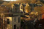
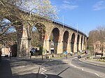
Neville's Cross is a place in County Durham, in England. It is also a ward of Durham with a population taken at the 2011 census of 9,940. It is situated on the A167 trunk road to the west of the centre of Durham. The area is primarily residential, although there is a newsagent, a Church, some public houses and two primary schools located there. The suburb was also home to part of New College Durham until the college consolidated onto its site at Framwellgate Moor in 2005.
Excerpt from the Wikipedia article Neville's Cross (License: CC BY-SA 3.0, Authors, Images).Neville's Cross
Cross View Lane, Durham Neville's Cross
Geographical coordinates (GPS) Address Nearby Places Show on map
Geographical coordinates (GPS)
| Latitude | Longitude |
|---|---|
| N 54.77245 ° | E -1.59335 ° |
Address
Neville's Cross
Cross View Lane
DH1 4PJ Durham, Neville's Cross
England, United Kingdom
Open on Google Maps


