place

Scarborough—Rouge River

CanElecResTopTest with bare yearFederal electoral districts of TorontoFormer federal electoral districts of OntarioScarborough, Toronto
Scarborough Rouge River

Scarborough—Rouge River was a federal electoral district in Ontario, Canada, that has been represented in the House of Commons of Canada between 1988 and 2015. However, as of the Fall 2015 federal election, part of this riding has been combined with the south-western part of the old riding Pickering—Scarborough East. The riding covered the northeast part of the Scarborough part of Toronto. It stretched from Highway 401 in the south to Steeles Avenue in the north. In the east it ended at the border with Pickering and in the west at Midland north of Finch and Brimley south of Finch. Scarborough—Rouge River has the highest percentage of visible minorities in all electoral districts (89.7%) and the lowest percentage of White Caucasians (10.1%). Chinese make up 30.8%, South Asian 32.8% (all South Asian countries), Black 10.7%, White 8.7% Tamil is the mother tongue for 13.2% of the population, which is the highest such percentage for that language among all ridings; likewise for Tamil as a home language (10.5%). 13.6% of the population is Hindu, the 2nd highest in Canada after Brampton East.In the 2011 federal election, the NDP were elected for the first time. The riding was abolished before the 2015 election. The western portion, along with most of its population, became part of Scarborough North, while the eastern portion became Scarborough—Rouge Park.

Excerpt from the Wikipedia article Scarborough—Rouge River (License: CC BY-SA 3.0, Authors, Images).

Scarborough—Rouge River
Old Finch Avenue, Toronto Scarborough

Geographical coordinates (GPS) Address Nearby Places
placeShow on map

Wikipedia: Scarborough—Rouge RiverContinue reading on Wikipedia

Geographical coordinates (GPS)

Latitude Longitude
N 43.826 ° E -79.197 °
placeShow on map

Address

Old Finch Avenue 6410
M1B 5J2 Toronto, Scarborough
Ontario, Canada
mapOpen on Google Maps

Scarborough Rouge River
Share experience

Nearby Places

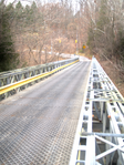
Old Finch Avenue Bailey Bridge

The Old Finch Avenue bridge is a Bailey bridge in Toronto. The Finch bridge is used for limited vehicular traffic on Old Finch Avenue in north-east Toronto to cross the Rouge River. The bridge dates back to late October 1954; it was constructed by the Canadian Army in three working days (including the timber piles supporting in mid-stream) using bridge components from the Ontario Hydro-Electric Power Commission, after Hurricane Hazel destroyed the old one. This bridge was built for single traffic; it is now controlled by traffic lights. The bridge is considered an historic landmark in Toronto, where the City of Scarborough council has erected a plaque beside the bridge which reads: BAILEY BRIDGE CONSTRUCTION 2ND FIELD ENGINEER REGIMENT On October 15, 1954, Hurricane Hazel struck the Scarborough area with terrifying force, severely damaging or completely washing out several bridges. To maintain a safe flow of traffic throughout the Municipality, a number of Bailey Bridges were erected by the 2nd Field Engineer Regiment of the Canadian Military Engineers. This bridge is the last of those remaining in service in Scarborough. This plaque serves to commemorate the efforts of the 2nd Field Engineer Regiment in meeting this natural disaster. There are two other Bailey bridges in the Greater Toronto Area: Lake Shore Boulevard Bailey Bridge in Toronto 16th Avenue Bailey Bridge in Markham (16th Avenue east of Reesor Road)