place

Morningside Heights, Toronto

AC with 0 elementsNeighbourhoods in TorontoScarborough, Toronto
Thomas Wells PS
Thomas Wells PS

Morningside Heights is a residential neighbourhood in the district of Scarborough in Toronto, Ontario, Canada. It is located in the northeast corner of the city, just north of the Malvern and west of Rouge Park and the Rouge. The subdivision, comprising approximately 750 acres (3.0 km2), was one of the last large tracts of undeveloped land within the City of Toronto, located between Finch Avenue East and Steeles Avenue East, from Tapscott Road to the Rouge River.The area is named after Morningside Avenue, which was extended north into the neighbourhood. The northern section of Morningside Heights is also known as Brookside. The community is divided, north and south, by hydro lines that cut across the development. The name Brookside originates from a golf course that was once on the site, northeast of the intersection of Oasis Boulevard and Seasons Drive. Local residents formed the Morningside Heights Neighbourhood Association in 2015. In 2018, it was registered with the Ontario Ministry of Government and Consumer Services as a not-for-profit group.

Excerpt from the Wikipedia article Morningside Heights, Toronto (License: CC BY-SA 3.0, Authors, Images).

Morningside Heights, Toronto
Morningside Avenue, Toronto Scarborough

Geographical coordinates (GPS) Address Nearby Places
placeShow on map

Wikipedia: Morningside Heights, TorontoContinue reading on Wikipedia

Geographical coordinates (GPS)

Latitude Longitude
N 43.82 ° E -79.218333333333 °
placeShow on map

Address

Morningside Avenue 2133
M1X 1Y3 Toronto, Scarborough
Ontario, Canada
mapOpen on Google Maps

Thomas Wells PS
Thomas Wells PS
Share experience

Nearby Places

Old Finch Avenue Bailey Bridge

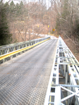
The Old Finch Avenue bridge is a Bailey bridge in Toronto. The Finch bridge is used for limited vehicular traffic on Old Finch Avenue in north-east Toronto to cross the Rouge River. The bridge dates back to late October 1954; it was constructed by the Canadian Army in three working days (including the timber piles supporting in mid-stream) using bridge components from the Ontario Hydro-Electric Power Commission, after Hurricane Hazel destroyed the old one. This bridge was built for single traffic; it is now controlled by traffic lights. The bridge is considered an historic landmark in Toronto, where the City of Scarborough council has erected a plaque beside the bridge which reads: BAILEY BRIDGE CONSTRUCTION 2ND FIELD ENGINEER REGIMENT On October 15, 1954, Hurricane Hazel struck the Scarborough area with terrifying force, severely damaging or completely washing out several bridges. To maintain a safe flow of traffic throughout the Municipality, a number of Bailey Bridges were erected by the 2nd Field Engineer Regiment of the Canadian Military Engineers. This bridge is the last of those remaining in service in Scarborough. This plaque serves to commemorate the efforts of the 2nd Field Engineer Regiment in meeting this natural disaster. There are two other Bailey bridges in the Greater Toronto Area: Lake Shore Boulevard Bailey Bridge in Toronto 16th Avenue Bailey Bridge in Markham (16th Avenue east of Reesor Road)