place

New England Island

Essex geography stubsIslands of EssexRochford DistrictUninhabited islands of England
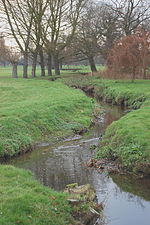
Road over New England Island geograph.org.uk 901301

New England Island is an uninhabited island in Essex, England. One road crosses the island, connecting it with bridges to Foulness and to the mainland via Havengore Island. Formerly used as pasture for livestock, the low-lying island is protected by levees and has been owned by the Ministry of Defence since the early 20th century.

Excerpt from the Wikipedia article New England Island (License: CC BY-SA 3.0, Authors, Images).

New England Island
Essex

Geographical coordinates (GPS) Address Nearby Places
placeShow on map

Wikipedia: New England IslandContinue reading on Wikipedia

Geographical coordinates (GPS)

Latitude Longitude
N 51.57426 ° E 0.84872 °
placeShow on map

Address

Havengore Head


SS3 9XD Essex, Foulness
England, United Kingdom
mapOpen on Google Maps

Road over New England Island geograph.org.uk 901301
Share experience

Nearby Places

Wallasea Wetlands
Wallasea Wetlands

Wallasea Wetlands is a reclaimed wetlands area located in Essex, England. It has been created as part of a government-funded wetlands scheme to halt the decline of wild and endangered birds caused by the drainage and development of former wetland sites. It is the largest man-made marine wetland area in the United Kingdom. The wetland spans an area of 115 hectares (1.15 km2) and is sited on Wallasea Island, which borders two rivers (River Crouch to the north and River Roach to the south-east). They provide winter grounds for wading birds, as well as breeding and nursery areas for aquatic wildlife, such as bass, mullet, flatfish and herring and even some types of dolphin. The area will also help to reduce the flooding of properties near the River Crouch by providing a run-off area for floodwaters. In the process being termed "managed re-alignment", the seawall that protects croplands and property was re-established in more tenable positions, three miles behind the new wetlands, which will provide habitat for birds like oystercatchers, avocets and little terns, according to the press release issued at the time. Walkers and birdwatchers will be able to enjoy the scenery by means of a new footpath that has been built on the top of this new relocated sea wall. Construction was completed in 2006 and by 2011 the land had evolved into wetland, mudflats, saline lagoons and seven artificial islands, allowing the wildlife to reside on these areas. An extension to the scheme, using 2,400 shiploads of spoil excavated from London's Crossrail tunnels, was completed in July 2015, when an additional area of land was opened to tidal flow. This has formed the Jubilee Marsh (160 ha / 400 acres). The whole project is expected to be completed by 2025.

River Roach
River Roach

The River Roach is a river that flows entirely through the English county of Essex. It is one of four main streams that originate in the Rayleigh Hills to the west, and flow east. They then flow towards the centre of the Rochford Basin, a circular feature which may have been caused by an asteroid impact in the Late Oligocene or Early Miocene periods. To the east of Rochford, the river becomes tidal, and is governed by the Crouch Harbour Authority. It joins the River Crouch between Wallasea Island and Foulness Island. To the west of Rochford, there is some doubt as to which of the four streams is officially the Roach. At Stambridge, there was a tidal mill from at least the 1500s, although few details are known until it was rebuilt in 1809. A pound was filled by the incoming tide, and was released to drive a water wheel as the tide fell. On spring tides, this gave around 7 hours of operation, which gradually decreased as the tides reduced, and at neap tides, the operation of the mill was entirely dependent on the flow from the upper river. Rankins, the millers, objected to plans by the Great Eastern Railway to build a dam and reservoirs in Rochford, as it would damage their operation, but a single reservoir was authorised in 1904. The river channels are designated as "heavily modified" from their natural state by the Environment Agency, who measure the water quality. This is moderate for most of the tributaries, and the chemical status has improved since 2013. Charles Darwin's HMS Beagle was moored on the river from 1850 as a Coast Guard watch ship. It was sold for breaking, but an archaeological survey concluded in 2008 that much of it still remains buried beneath the mud near Paglesham. The Paglesham Reach is also significant for its native oysters.

Saint Mary the Virgin, Foulness Island

Saint Mary the Virgin is a parish of the Church of England on Foulness Island, in Essex, England. Before the 15th century, the island of Foulness was divided among several neighbouring parishes. The inhabitants were expected to attend church services in their respective mainland parish churches but in practice this must have been difficult and at times impossible, as in those days there was no bridge linking Foulness to the mainland.In 1407, Lady Joan de Bohun, Countess of Essex, obtained a licence from the Bishop of London to found a chantry of a chaplain to celebrate Mass on a daily basis in a chapel on Foulness. She also managed to secure the payment of church dues towards the upkeep of the chapel, rather than having the islanders’ payments going towards the various mainland parishes among which the island had been split.Some 150 years later, the Chantry was dissolved under the massive religious upheaval resulting from Henry VIII's Dissolution of the Monasteries. The chapel's land and possessions were confiscated. However, the desire for local services remained and within three years Foulness became a separate ecclesiastical parish.The old chantry chapel was demolished and a new timber-framed church was erected on the site, this church being dedicated to St Mary the Virgin. By the middle the 19th century this old church was in a poor state of repair and the size of the population of the parish had outgrown the small building. In 1848 the parishioners decided to pull the old church down and build a new one in its place.The present church, which is now Grade II listed, was erected a little to the west of the original site. The parishioners themselves provided some forty per cent of the cost of building, and George Finch, the then Lord of the Manor, twenty per cent. The rest came from two ecclesiastical building societies and from private subscription, including £50 from the Elder Brethren of Trinity House so that the spire might be built of a sufficient height to be of value as a seamark for sailors.The church was built in the Early English style, to a design by William Hambley, with a spire, a nave with two aisles, and a chancel. The churchyard was expanded, using ground given by George Finch. The new church was consecrated in 1853 and dedicated to "Saint Mary the Virgin, Saint Thomas and All Saints".The church is quite plain inside, with almost no stained glass. The organ was built in 1866 and gained “a gold medal at an exhibition” but the brass plaque attached to it does not tell us which exhibition; it was purchased from North Ockendon and dedicated in 1908. A swell was added to commemorate the Silver Jubilee of George VI and was dedicated in October 1936. Although no obvious evidence remains of the earlier church buildings, there are several gravestones which clearly predate the present building., including one for Jonas Allen who died on 27 April 1698, which carries a skull and crossbones motif. There are also three War Graves from the First World War containing the remains of unidentified Royal Navy sailors whose bodies were found on the coast of the island. Inside the main gate of the churchyard is the island's War Memorial. On one face are listed the names of seven Islanders who gave their lives in the “Great War”, and on an adjoining face the names of the three who died in the Second World War. The church was permanently closed in May 2010, and the building was later put up for sale. In 2019 there were plans for it to become a five-bedroom home.