place

Rochford and Southend East (UK Parliament constituency)

Constituencies of the Parliament of the United Kingdom established in 1997EngvarB from October 2013Parliamentary constituencies in EssexPolitics of Southend-on-Sea
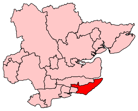
RochfordSouthendEast2007Constituency

Rochford and Southend East is a constituency represented in the House of Commons of the UK Parliament since 2005 by Sir James Duddridge, a Conservative.Under the 2023 Periodic Review of Westminster constituencies, the constituency will only be subject to relatively minor boundary changes (including the loss of St Luke's ward to Southend West), but is to be renamed Southend East and Rochford - to be first contested at the next general election.

Excerpt from the Wikipedia article Rochford and Southend East (UK Parliament constituency) (License: CC BY-SA 3.0, Authors, Images).

Rochford and Southend East (UK Parliament constituency)
Conway Avenue, Essex

Geographical coordinates (GPS) Address Nearby Places
placeShow on map

Wikipedia: Rochford and Southend East (UK Parliament constituency)Continue reading on Wikipedia

Geographical coordinates (GPS)

Latitude Longitude
N 51.55 ° E 0.81 °
placeShow on map

Address

Conway Avenue

Conway Avenue
SS3 0DD Essex, Great Wakering
England, United Kingdom
mapOpen on Google Maps

RochfordSouthendEast2007Constituency
Share experience

Nearby Places

Danish Camp
Danish Camp

Danish Camp is an Iron Age fortified settlement in Shoeburyness in Essex. It is a Scheduled Monument under the Ancient Monuments and Archaeological Areas Act 1979, list number 1017206. The site is in the Gunners Park and Shoebury Ranges nature reserve, which is managed by the Essex Wildlife Trust.This site is classed by Natural England as a 'slight univallate hillfort'. There are two sections remaining of the defensive banks of the settlement. The surviving part of the north-western bank is around 80 metres long, and it has an average height of 2 metres and width of 11 metres. The southern bank is slightly lower. There was an external ditch, which is now largely filled. Pottery vessels have been found dating to the Middle Iron Age, around 400 to 200 years BC, together with four round houses and many post holes and pits. There is some evidence of earlier Mesolithic and Bronze Age occupation, but as this extends beyond the site it is thought to represent general utilisation of the area. The site was agricultural land until it was purchased by the Board of Ordnance in 1849, and some of the visible Iron Age remains were probably lost at that time, while other parts have been lost to coastal erosion. There is also evidence of Roman occupation in the south-west corner.The site is called the Danish Camp because it was thought to have been constructed by the Danish Viking leader Hastein, who is reported by the Anglo-Saxon Chronicle to have built a fort at Shoebury in 894; though he might have re-used the existing camp, no evidence has been found of Viking occupation.There is public access to the site, which is between Ness Road and Warrior Square Road.