São Vicente Island (São Paulo, Brazil)
Atlantic islands of BrazilBaixada SantistaLandforms of São Paulo (state)São Paulo (state) geography stubs

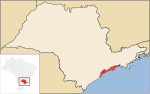
São Vicente Island (São Paulo, Brazil) is an island in São Paulo state, Brazil. It has an area of 57.4 km2 and a population of 760,000 people. The population density is 13,240/ km2, making it the most densely populated island in Brazil, and the 38th most densely populated island in the world. Parts of the cities of São Vicente and Santos are located on the island. The former sugar cane facility, Engenho dos Erasmos is situated here.
Excerpt from the Wikipedia article São Vicente Island (São Paulo, Brazil) (License: CC BY-SA 3.0, Authors, Images).São Vicente Island (São Paulo, Brazil)
Rua Padre Anchieta, Santos Morro Cachoeira (Santos)
Geographical coordinates (GPS) Address Nearby Places Show on map
 Continue reading on Wikipedia
 Geographical coordinates (GPS)
| Latitude | Longitude |
|---|---|
| N -23.95 ° | E -46.36 ° |
Address
Rua Padre Anchieta (Rua dos Invalidos)
Rua Padre Anchieta
11085-625 Santos, Morro Cachoeira (Santos)
São Paulo, Brazil
Open on Google Maps