place

Patapsco station

1992 establishments in MarylandBaltimore Light Rail stationsCherry Hill, BaltimoreMaryland railway station stubsRailway stations in Baltimore County, Maryland
Railway stations in the United States opened in 1992Tram stubs
MTA Maryland 9863
MTA Maryland 9863

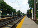
Patapsco station is a Baltimore Light Rail station in Halethorpe, Maryland. The stop is located along Patapsco Avenue from which its name is derived. The station serves as a hub for several MTA bus routes. Patapsco was the final stop along the line for a period from September 1992 until April 1993, when the line was extended to Linthicum. The station has 216 spaces for commuters, some of that allow for overnight parking. Patapasco station was the original northern terminus of the Baltimore and Annapolis Railroad, which connected to the Curtis Bay Branch of the Baltimore and Ohio Railroad. Bus routes 14, 75, 51, 77 and the Patapsco branch of CityLink Yellow lay over at the station. Route 16 also passes through the station in both directions along its route.

Excerpt from the Wikipedia article Patapsco station (License: CC BY-SA 3.0, Authors, Images).

Patapsco station
West Patapsco Avenue, Baltimore

Geographical coordinates (GPS) Address Nearby Places
placeShow on map

Wikipedia: Patapsco stationContinue reading on Wikipedia

Geographical coordinates (GPS)

Latitude Longitude
N 39.241975 ° E -76.629852777778 °
placeShow on map

Address

West Patapsco Avenue
21225 Baltimore
Maryland, United States
mapOpen on Google Maps

MTA Maryland 9863
MTA Maryland 9863
Share experience

Nearby Places

Hanover Street Bridge

The Hanover Street Bridge – officially, the Vietnam Veterans Memorial Bridge – is a bascule bridge crossing the middle branch of the Patapsco River along Hanover Street (Maryland Route 2) in Baltimore, Maryland. The bridge was built to replace the mile-long "Long Bridge" built by Richard Cromwell in 1856 to move products from his orchard in Anne Arundel County to downtown Baltimore.The Hanover Street Bridge connects the southern base of the industrialized South Baltimore to the neighborhood of Cherry Hill and Brooklyn. The bridge carries five lanes of traffic: two northbound, two southbound, and one reversible. It employs a lane control system and carries two sidewalks on either side. Designed by J. E. Greiner Company, the bridge was constructed in 1916 and is characterized as a Beaux Arts-style reinforced cantilever bridge. It is known for its beautiful arches as it spans the water. In the center of the bridge is a drawbridge span surrounded on four corners by classic style towers which lend it a distinctive appearance. The bridge is 2,290 feet (700 m) long. On May 30, 1993, Baltimore Mayor Kurt Schmoke officially renamed the bridge the "Vietnam Veterans Memorial Bridge". In the 1990s, the area under the bridge became the site of a rough and sometimes murderously violent "tent city" campsite for the homeless.As of January 2016, the bridge is in a state of disrepair, riddled with numerous potholes – some exposing the rebar below.