place

Hanover Street Bridge

Bascule bridges in the United StatesBeaux-Arts architecture in MarylandBridges completed in 1916Cantilever bridges in the United StatesCrossings of the Patapsco River
Maryland building and structure stubsMaryland transportation stubsMonuments and memorials in MarylandRoad bridges in MarylandSouthern United States bridge (structure) stubsVietnam War monuments and memorials in the United States
Hanover street bridge baltimore

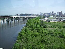
The Hanover Street Bridge – officially, the Vietnam Veterans Memorial Bridge – is a bascule bridge crossing the middle branch of the Patapsco River along Hanover Street (Maryland Route 2) in Baltimore, Maryland. The bridge was built to replace the mile-long "Long Bridge" built by Richard Cromwell in 1856 to move products from his orchard in Anne Arundel County to downtown Baltimore.The Hanover Street Bridge connects the southern base of the industrialized South Baltimore to the neighborhood of Cherry Hill and Brooklyn. The bridge carries five lanes of traffic: two northbound, two southbound, and one reversible. It employs a lane control system and carries two sidewalks on either side. Designed by J. E. Greiner Company, the bridge was constructed in 1916 and is characterized as a Beaux Arts-style reinforced cantilever bridge. It is known for its beautiful arches as it spans the water. In the center of the bridge is a drawbridge span surrounded on four corners by classic style towers which lend it a distinctive appearance. The bridge is 2,290 feet (700 m) long. On May 30, 1993, Baltimore Mayor Kurt Schmoke officially renamed the bridge the "Vietnam Veterans Memorial Bridge". In the 1990s, the area under the bridge became the site of a rough and sometimes murderously violent "tent city" campsite for the homeless.As of January 2016, the bridge is in a state of disrepair, riddled with numerous potholes – some exposing the rebar below.

Excerpt from the Wikipedia article Hanover Street Bridge (License: CC BY-SA 3.0, Authors, Images).

Hanover Street Bridge
South Hanover Street, Baltimore

Geographical coordinates (GPS) Address External links Nearby Places
placeShow on map

Wikipedia: Hanover Street BridgeContinue reading on Wikipedia

Geographical coordinates (GPS)

Latitude Longitude
N 39.257777777778 ° E -76.616277777778 °
placeShow on map

Address

Hanover Street Bridge

South Hanover Street
21230 Baltimore
Maryland, United States
mapOpen on Google Maps

linkWikiData (Q5649431)
linkOpenStreetMap (574956389)

Hanover street bridge baltimore
Share experience

Nearby Places

Riverside Park (Baltimore)

Riverside Park is a nearly 17-acre (6.9 ha) public park located in the historic Riverside neighborhood in Baltimore, Maryland. Early in Baltimore history, the site of Riverside Park was often used as a lookout point because of the clear view it offered of the South Baltimore peninsula and the Patapsco River. Because of this, during the War of 1812 Major General Samuel Smith ordered Captain Samuel Babcock to build a circular battery at the location, called Fort Lookout. Commanded by Lt. George Budd during the Battle of Baltimore, the battery played a key role in the defense of Baltimore. Combined with the garrisons at Forts Covington and Babcock, the forces at Fort Lookout assisted in repelling a British attempt to assault the peninsula by land, saving the city. After the battle, the fort was renamed Fort Wood in honor of Colonel Eleazer Wood, and the site remained in limited use through the mid-1800s.In 1854, Baltimore applied to condemn 3 acres for public use along Randall, Covington and Heath Streets and rename the property Battery Square. The city formally acquired the 3-acre square in 1862 from James Polk. In 1873, the city acquired an additional 14 acres to the south of Battery Square and renamed the property Riverside Park, making it one of the oldest parks in the city system. In 1876, the city passed an ordinance putting the park under control of the Public Park Commission.During the Baltimore Railroad Riots of 1877, the park served as an encampment for the 5th Regiment of the Maryland National Guard. After assisting with the riots downtown, the regiment marched to Riverside Park on July 30 to help guard the South Baltimore rail lines. On August 1, the regiment put on an exhibition for the local residents.In the following years, the Public Park Commission made several improvements to the park: a large marble fountain in the center, a nursery, iron railings, and gas lighting. Large attendances (in the thousands) were not unknown in the late 1800s. A swimming pool, playgrounds, and sports fields and courts were added at various times during the 20th century. Concerts and events at the gazebo, which are held to this day, were a popular attraction for the local citizens and provided a welcome distraction for the immigrant community that sprouted around the park.Baltimore City Rec and Parks announced in 2019 that it has developed plans for athletic field improvements and a fieldhouse renovation at Riverside Park. Overall, field improvements will consist of new lights, backstops, dugouts, fencing, basketball court, field drainage, and grass. The fields will be reconfigured to incorporate the CSX property that the city acquired along Wells street. Plans have been developed for the fieldhouse to renovate the bathrooms, storage areas, concession area, and seating.