place

Portsmouth Harbour

Competent harbour authoritiesEngvarB from October 2013Geography of HampshireGosportPorts and harbours of Hampshire
PortsmouthRamsar sites in EnglandSites of Special Scientific Interest in HampshireSpecial Protection Areas in EnglandTourist attractions in PortsmouthTransport in Portsmouth
Portsmouth harbour England panoramio

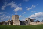
Portsmouth Harbour is a 1,264.2-hectare (3,124-acre)/12.6 km2 (4.9 sq mi) biological Site of Special Scientific Interest between Portsmouth and Gosport in Hampshire. It is a Ramsar site and a Special Protection Area. It is a large natural harbour in Hampshire, England. Geographically it is a ria: formerly it was the valley of a stream flowing from Portsdown into the Solent. At its north end is Portchester Castle, of Roman origin and the first fortress built to protect the harbour. The mouth of the harbour provides access to the Solent. It is best known as the home of the Royal Navy, HMNB Portsmouth. Because of its strategic location on the south coast of England, protected by the natural defence of the Isle of Wight, it has since the Middle Ages been the home to England's (and later Britain's) navy. The narrow entrance, and the forts surrounding it gave it a considerable advantage of being virtually impregnable to attack from the sea. Before the fortifications were built the French burned Portsmouth in 1338. During the civil war parliamentary forces were able to carry out a successful cutting-out expedition within the harbour and capture the six-gunned Henrietta Marie.In modern times, the harbour has become a major commercial ferry port, with regular services to Caen, France, Cherbourg, France, St Malo, France, The Channel Islands and the Isle of Wight. There is a passenger ferry to Gosport. It is also a major area for leisure sailing. In 2001 the Gunwharf Quays development, was opened on the site of HMS Vernon (a former naval shore establishment).

Excerpt from the Wikipedia article Portsmouth Harbour (License: CC BY-SA 3.0, Authors, Images).

Portsmouth Harbour
Portsmouth

Geographical coordinates (GPS) Address Nearby Places
placeShow on map

Wikipedia: Portsmouth HarbourContinue reading on Wikipedia

Geographical coordinates (GPS)

Latitude Longitude
N 50.8235 ° E -1.1228 °
placeShow on map

Address

Tipner


PO2 8RD Portsmouth
England, United Kingdom
mapOpen on Google Maps

Portsmouth harbour England panoramio
Share experience

Nearby Places

Portchester Castle
Portchester Castle

Portchester Castle is a medieval fortress that was developed within the walls of the Roman Saxon Shore fort of Portus Adurni at Portchester, to the east of Fareham in Hampshire. The keep was probably built in the late 11th century as a baronial castle and Portchester was taken under royal control in 1154. The monarchy controlled the castle for several centuries and it was a favoured hunting lodge of King John. It was besieged and captured by the French in 1216 before permanently returning to English control shortly thereafter. Occupying a commanding position at the head of Portsmouth Harbour, in the medieval period Portchester was an important port. The castle saw the embarkation for several campaigns to France led by England's kings. In anticipation of a French invasion during the first quarter of the 14th century, Edward II spent £1,100 repairing and reinforcing Portchester Castle. A plot to overthrow Henry V was discovered and the culprits apprehended at Portchester; this event features in Shakespeare's play, Henry V. Later in its history, the castle was used as a prison. Today Portchester Castle is a Scheduled Ancient Monument, and a Grade I listed building. The castle has been in the ownership of the Southwick Estate since the 17th century but is managed by English Heritage and open to visitors throughout the year. The Norman church, St. Mary's, which stands in the south-east corner of the grounds, falls within the Anglican Diocese of Portsmouth.

Burrow Island
Burrow Island

Burrow Island (also known as 'Rat Island' or 'Ratty') is a tidal island in Gosport, United Kingdom. The island overlooks Portsmouth harbour. At low tide a spit connects it with Priddy's Hard. It has been suggested that the name dates from the 17th century and is derived from being within the borough of Gosport.Between 1678 and 1679, a fortification named Fort James was constructed on the island under the direction of Bernard de Gomme. It took the form of a square tower 19 ft tall. The fortification was apparently allowed to decay with George Byng commenting on its poor condition in a letter written in either 1707 or 1708. It appears that a rebuilding to a new design was proposed on 1750 but this never took place. What were by then the ruins of the fort were partially demolished in 1827 and nothing now remains above ground level. It has been claimed that King Stephen built a fortification on the island but this is unlikely to have been the case.Burrow Island is owned by the Ministry of Defence, and public access is not permitted; despite this, at low tide some members of the public have ventured onto Burrow Island. It is a popular spot to go fishing. It is known that some have found unique coloured glass bottles that had been washed up on the island. Burrow Island was once used as a burial ground for convicts; several human skeletons were discovered on the island early in 2014. They are believed to be from the 19th century and are the remains of convicts or prisoners of war who had been buried on the island.Burrow Island is one of 43 (unbridged) tidal islands which can be walked to from the mainland of Great Britain.