place

Priddy's Hard

Ammunition dumps in EnglandGosportGovernment munitions production in the United KingdomTourist attractions in HampshireUse British English from October 2019
Earthwork Defences at Priddy's Hard

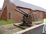
Priddy's Hard is a former military installation in Gosport, England named for the original landowner and the firm beach found there. The site originated as a 1750s fort, and then became an armaments depot for Royal Navy and British Army weapons, explosives and other stores. The site was decommissioned in 1988, after over two hundred years of operation, with part now being developed for housing and an area retained as a museum.

Excerpt from the Wikipedia article Priddy's Hard (License: CC BY-SA 3.0, Authors, Images).

Priddy's Hard
Heritage Way,

Geographical coordinates (GPS) Address Nearby Places
placeShow on map

Wikipedia: Priddy's HardContinue reading on Wikipedia

Geographical coordinates (GPS)

Latitude Longitude
N 50.806666666667 ° E -1.1255555555556 °
placeShow on map

Address

Explosion! Museum of Naval Firepower

Heritage Way
PO12 4WF , Priddy's Hard
England, United Kingdom
mapOpen on Google Maps

Earthwork Defences at Priddy's Hard
Share experience

Nearby Places

Burrow Island
Burrow Island

Burrow Island (also known as 'Rat Island' or 'Ratty') is a tidal island in Gosport, United Kingdom. The island overlooks Portsmouth harbour. At low tide a spit connects it with Priddy's Hard. It has been suggested that the name dates from the 17th century and is derived from being within the borough of Gosport.Between 1678 and 1679, a fortification named Fort James was constructed on the island under the direction of Bernard de Gomme. It took the form of a square tower 19 ft tall. The fortification was apparently allowed to decay with George Byng commenting on its poor condition in a letter written in either 1707 or 1708. It appears that a rebuilding to a new design was proposed on 1750 but this never took place. What were by then the ruins of the fort were partially demolished in 1827 and nothing now remains above ground level. It has been claimed that King Stephen built a fortification on the island but this is unlikely to have been the case.Burrow Island is owned by the Ministry of Defence, and public access is not permitted; despite this, at low tide some members of the public have ventured onto Burrow Island. It is a popular spot to go fishing. It is known that some have found unique coloured glass bottles that had been washed up on the island. Burrow Island was once used as a burial ground for convicts; several human skeletons were discovered on the island early in 2014. They are believed to be from the 19th century and are the remains of convicts or prisoners of war who had been buried on the island.Burrow Island is one of 43 (unbridged) tidal islands which can be walked to from the mainland of Great Britain.

Royal Clarence Yard
Royal Clarence Yard

Royal Clarence Yard in Gosport, Hampshire, England was established in 1828 as one of the Royal Navy's two principal, purpose-built, provincial victualling establishments (the other being Royal William Yard in Plymouth, Devon). It was designed by George Ledwell Taylor, Civil Architect to the Navy Board and named after the then Duke of Clarence (later William IV, King of England). The new victualling yard was developed on approximately 20 hectares of land, some of which was already in use as a brewing establishment at Weevil on the west shore of Portsmouth Harbour, to the north of Gosport. Queen Victoria regularly used Royal Clarence Yard as her disembarkation point for the short journey across the Solent to her house at Osborne in the Isle of Wight, travelling from Gosport Station on the single track line extension which had been opened in 1844 principally for this purpose.Between the establishment of the Yard and its eventual decommissioning in the early 1990s, Royal Clarence Yard supplied provisions to the Royal Navy in all the major conflicts of this period.In 1995, the Ministry of Defence (MoD) declared 16.26 hectares of Royal Clarence Yard surplus to requirements and released it to Gosport Borough Council. Berkeley Homes bid for the land in 1998 and was granted planning permission for a mixed use development in 2001. The south-eastern part of the Yard (approx 3,74 hectares), which includes the Oil and Pipelines Agency access to the Gosport Oil Fuel Depot, was retained by the MoD for operational reasons. In 2014, the Defence Infrastructure Organisation announced plans to release most of the rest of the retained land at Royal Clarence Yard to Gosport Borough Council.