place

La Raza metro station

1978 establishments in Mexico1982 establishments in MexicoAC with 0 elementsAccessible Mexico City Metro stationsInterlanguage link template existing link
Mexico City Metro Line 3 stationsMexico City Metro Line 5 stationsMexico City Metro stations in Gustavo A. Madero, Mexico CityRailway stations opened in 1978Railway stations opened in 1982Use American English from April 2020
Metro CDMX IMG 1596 (28169582912)

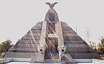
La Raza (Mexican Spanish: [la 'ra.sa] (listen); Spanish transl. "the People"; lit. transl. "the Race") is a Mexico City Metro transfer station in the Gustavo A. Madero borough of Mexico City. It is a combined underground and at-grade station with two side platforms each, served by Lines 3 (the Olive Line) and 5 (the Yellow Line). La Raza station is located between Potrero and Tlatelolco stations on Line 3, and between Autobuses del Norte and Misterios stations on Line 5. It serves the colonias (neighborhoods) of Vallejo and Héroes de Nacozari. The station's pictogram depicts the nearby Monumento a la Raza, a pyramid-shaped construction erected in honor of la Raza, Mexico's many native peoples and cultures. La Raza station opened on 25 August 1978 with service on Line 3 southward toward Hospital General station. Southeasterly service on Line 5 toward Pantitlán station began on 1 July 1982. The station facilities are partially accessible for people with disabilities as there are braille signage plates; inside, there is an Internet café, a library, and a mural titled Monstruos de fin de milenio, painted by Ariosto Otero Reyes. Outside, there is a bicycle parking station and a bus terminal. In 2019, the station had an overall average daily ridership of 40,937 passengers. The transfer tunnel has an approximate length of 600 meters (2,000 ft), the second-longest in the system. Inside the tunnel, there is a permanent science exhibition called El Túnel de la Ciencia ("The Tunnel of Science"), installed by the National Autonomous University of Mexico (UNAM) to provide scientific information to passengers, which was opened on 30 November 1988. The exposition features information about science and astronomy using pictures.

Excerpt from the Wikipedia article La Raza metro station (License: CC BY-SA 3.0, Authors, Images).

La Raza metro station
Avenida Lázaro Cárdenas, Mexico City

Geographical coordinates (GPS) Address Nearby Places
placeShow on map

Wikipedia: La Raza metro stationContinue reading on Wikipedia

Geographical coordinates (GPS)

Latitude Longitude
N 19.470153 ° E -99.136891 °
placeShow on map

Address

Metro La Raza

Avenida Lázaro Cárdenas
07870 Mexico City
Mexico
mapOpen on Google Maps

Metro CDMX IMG 1596 (28169582912)
Share experience

Nearby Places

Colonia San Simón Tolnáhuac

Colonia San Simón Tolnáhuac is a colonia in the Cuauhtémoc borough of Mexico City, just north of the city's historic center. The colonia's borders are marked by the following streets: Eje 1 Poniente to the south, Avenida Rio Consulado to the north, Lerdo Street and Calzada Vallejo to the east and Avenida de los Insurgentes Norte to the west.This area originally was part of the Tlatelolco dominion and functioned as communal farmland through most of the pre-Hispanic and colonial periods. Its center was the village of San Simon Tolnáhuac. Tolnáhuac comes from Nahuatl and means “in reeds.” Around 1873, some of the farmland around here began to be subdivided and this subdivision called Cuitlahuac Ferrocarrilera. This subdivision was mostly populated by railroad workers who worked at the nearby Nonoalco station. This station was located at what is now the corner of Manuel González and Lerdo Street and belonged to the Monte Alto rail company. The main tracks were where San Simon Atlampa Street is now and at that time, divided the zone in half. By 1928, it was still the last independent village just north of the Mexico City's historic center, when it was finally incorporated. In 2008, the borough sponsored the twelfth “Rescue of the Urban Image of the Habitational Units in San Simón Tolnáhuac. The goal of the program is to maintain and repair aspects of large apartment units such as repairs of walls, courtyards, facades, railings and fences as well as maintenance work on lighting and sewer and other projects. That year, the focus was on several units on Jupiter Street. This program is a spinoff of the Rescue of the Urban Image of Green and Recreation Areas. In 2009, the borough announced the construction of a cultural center for the colonia.Schools in the colonia include the Centro de Integracion Infantil Carrusel preschool (private), Francisco Diaz Covarrubias primary school (public), Kinder las Rositas preschool (private), Mi Arco Iris preschool (private), Professor Luis de la Brina primary school (public) and the Tres Culturas primary school (private) .

Colonia Santa María Insurgentes

Colonia Santa María Insurgentes is a colonia in the Cuauhtémoc borough north east of the Mexico City’s historic center. The colonia’s borders are formed by the following roads: Calzada de San Simon to the south, Jacarandas to the north, Avenida de los Insurgentes Norte to the east and Jacarandas to the west.The official establishment of the colonia occurred in 1910, but there had been named streets and laid out blocks for some time before this. The land here belonged to the El Chopo Ranch before much of it was sold and eventually subdivided. The government order establishing the colonia mandates the conservation of the layout and street names. However, the colonia did not receive its name until 1950, when it was expanded. The area was originally conceived to be residential, but much of it became industrial. Today, much of the area is still industrial, with major facilities such as those belonging to Unilever on Rio Consulado.Area schools include Cecyt Num. 12, Jose Maria Morelos y Pavon technical school (public), Colegio Bilingue Madison primary (private), and Escuela Secundaria y Preparatoria Justo Sierra, Plantel Azahares (middle and high school) (private) .The Tren Suburbano commuter line crosses through the colonia as it connects downtown Mexico City with suburbs to the north of the city. Neighbors both in this colonia and neighboring Colonia Atlampa have complained that the train, built in the 2000s, has brought more crime to an area that already has serious problems of this type. They also claim that the rail line causes traffic jams, especially as the trains go over the speed limit and disregard traffic signals on streets such as Geranio, San Simon, Mimosas and Cipres.Even without the suburban train, traffic is problematic in the colonia. One bad intersection, reported by El Universal newspaper, is Eje 2 Norte and Geranio, where micros (small privately owned busses) routinely ignore traffic signals and police are either non-existent. On a number of other roads, driver frequently take shortcuts over roads going against traffic. Streets such as Oyamel, Abedules and Mimosas have many potholes.The colonia has long had crime problems especially from youths as they leave school for the day. Crimes include vandalism, drug use and sales and the stealing of cars. Residents claim that they have appealed to city and federal authorities for help but with no response. The colonia is home to one major tianguis, or open flea market, which is a cultural heritage from the pre-Hispanic era. It is called El Nopal. While it sells food, clothing and other everyday items, it has also been accused of trafficking in arms and other contraband.The Glorieta de la Raza is located on the extreme northeast of the colonia, and is a large 5-lane traffic circle with the Monumento a la Raza (Monument to the Race) in the center. It is an extremely busy intersection connecting Insurgentes Norte, Vallejo and Circuito Interior arteries. It was originally designed for cars and light trucks but many tractor trailers also use the intersection as well. This and speeding has caused frequent accidents on this circle.