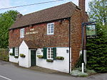
Hambledon, Hampshire

Hambledon is a small village and civil parish in the county of Hampshire in England, situated about 10 miles (16 km) north of Portsmouth within the South Downs National Park. Hambledon is best known as the 'Cradle of Cricket'. It is thought that Hambledon Club, one of the oldest cricket clubs known, was formed about 1750. Hambledon was England's leading cricket club from about 1765 until the formation of MCC (Marylebone Cricket Club) in 1787. The famous Bat and Ball Inn in Hyden Farm Lane is next to the historic cricket ground at Broadhalfpenny Down where the Hambledon club originally played. The inn was run by Richard Nyren, who was also captain of the club. The modern Hambledon Cricket Club's ground is at Ridge Meadow, about 0.5 miles (800 m) away. Hambledon is a rural village surrounded by fields and woods. There are about 400 households with just under 1,000 residents. The hamlet of Chidden, 2 miles (3.2 km) north of Hambledon, is in the parish. The nearest villages are Clanfield, Denmead and Soberton. Due to the climate and location Hambledon also has its very own vineyard, producing its own wine.
Excerpt from the Wikipedia article Hambledon, Hampshire (License: CC BY-SA 3.0, Authors, Images).Hambledon, Hampshire
Speltham Hill, Winchester Hambledon
Geographical coordinates (GPS) Address Nearby Places Show on map
Geographical coordinates (GPS)
| Latitude | Longitude |
|---|---|
| N 50.9307 ° | E -1.0799 ° |
Address
Speltham Hill
PO7 4RU Winchester, Hambledon
England, United Kingdom
Open on Google Maps


