Stonesfield

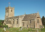
Stonesfield is a village and civil parish about 5 miles (8 km) north of Witney in Oxfordshire, and about 10 miles (17 km) north-west of Oxford. The village is on the crest of an escarpment. The parish extends mostly north and north-east of the village, in which directions the land rises gently and then descends to the River Glyme at Glympton and Wootton about 3 miles (5 km) to the north-east. South of Stonesfield, below the escarpment, is the River Evenlode which touches the southern edge of the parish. At the centre of Stonesfield stands the 13th-century church of St James the Great as well as a Wesleyan chapel, Stonesfield Methodist Church, slightly further west. The village is known for Stonesfield slate, a form of Cotswold stone mined particularly as a roofing stone and also a rich source of fossils. The architecture in Stonesfield features many old Cotswold stone properties roofed with locally mined slate along with some late 20th-century buildings and several properties under construction. The 2011 Census recorded the parish's population as 1,527.
Excerpt from the Wikipedia article Stonesfield (License: CC BY-SA 3.0, Authors, Images).Stonesfield
Church Street, West Oxfordshire Stonesfield
Geographical coordinates (GPS) Address Nearby Places Show on map
Geographical coordinates (GPS)
| Latitude | Longitude |
|---|---|
| N 51.851 ° | E -1.429 ° |
Address
Church Street
Church Street
OX29 8PS West Oxfordshire, Stonesfield
England, United Kingdom
Open on Google Maps


