I-35W Minnesota River bridge

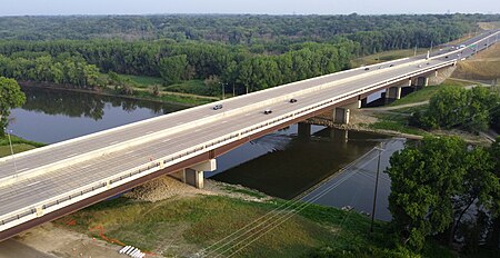
The I-35W Minnesota River Bridge connects the counties of Hennepin and Dakota, and the cities of Bloomington and Burnsville, over the Minnesota River. The bridge has eight lanes, four lanes in each direction. Inner lanes are MnPass HOV lanes, and a walking/bicycling path is located on the east side of the northbound span. The bridge is 1,361 feet (415 m) long, and 170 feet (52 m) wide. This bridge replaced a seven-lane steel girder bridge, constructed in 1960 by the Minnesota Highway Department. When it was built, it replaced a former bridge, located just to the east of the current bridge site, that carried US 65. Approaches to the former bridge had issues with flooding, with a 1965 flood putting the causeway just south of the bridge completely underwater. MnPass lanes were added in 2009.
Excerpt from the Wikipedia article I-35W Minnesota River bridge (License: CC BY-SA 3.0, Authors, Images).I-35W Minnesota River bridge
Blue Star Memorial Highway,
Geographical coordinates (GPS) Address External links Nearby Places Show on map
Geographical coordinates (GPS)
| Latitude | Longitude |
|---|---|
| N 44.8 ° | E -93.29 ° |
Address
I-35W Minnesota River bridge
Blue Star Memorial Highway
55337
Minnesota, United States
Open on Google Maps


