place

I-35W & 98th Street station

Bus station stubsBus stations in MinnesotaMinnesota transportation stubs
I 35W & 98th St station southbound complete

I-35W & 98th Street is a bus rapid transit station on the Metro Orange Line at 98th Street adjacent to Interstate 35W in Bloomington, Minnesota. The station is integrated with the South Bloomington Transit Center, a transfer hub and park and ride facility opened in 2004. The transit center was as far south as Route 535, predecessor to the Orange Line, traveled, with no direct connection to the other side of the Minnesota River. The station opened December 4, 2021 with the rest of the Orange Line. The parcels surrounding the station are being planned for a mix of transit oriented development.

Excerpt from the Wikipedia article I-35W & 98th Street station (License: CC BY-SA 3.0, Authors, Images).

I-35W & 98th Street station
West 99th Street,

Geographical coordinates (GPS) Address Nearby Places
placeShow on map

Wikipedia: I-35W & 98th Street stationContinue reading on Wikipedia

Geographical coordinates (GPS)

Latitude Longitude
N 44.825005 ° E -93.290632 °
placeShow on map

Address

South Bloomington Transit Center

West 99th Street
55420
Minnesota, United States
mapOpen on Google Maps

I 35W & 98th St station southbound complete
Share experience

Nearby Places

Gideon H. Pond House

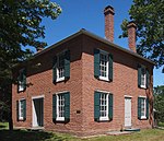
The Gideon H. Pond House is a historic house in Bloomington, Minnesota, United States. It is part of the Pond-Dakota Mission Park, which also includes the Oak Grove Mission site (1843–1852), a cemetery, and the remains of the Pond family farm and orchards. The site is significant within the history of the Minnesota River valley, the Dakota tribe, and Bloomington. The house is listed on the National Register of Historic Places. Gideon Hollister Pond (1810–1878) and his brother Samuel came to Minnesota with a mission to teach Christianity to the Indians and to teach them agriculture. The Ponds received permission in 1834 from Major Lawrence Taliaferro, the Indian agent at Fort Snelling, to establish a mission school near Bde Maka Ska (Lake Calhoun), where a band of Dakota spent their summers. Pond started work on writing a Dakota language dictionary. After a war broke out between the Dakota and the Ojibwa in 1839, the band of Dakota moved to a village near the Minnesota River, and Gideon Pond moved with them. He established a mission along the river bluffs. The area served as a mission between 1843 and 1852, when the Dakota were sent to a reservation further up the Minnesota River as a result of the Treaty of Traverse des Sioux. At that point, Pond bought this land and became a farmer. He also served as a member of Minnesota territorial House of Representatives 7th District, 1849–1850. Later, Pond started the Oak Grove Presbyterian Church, which was originally located on land which is now the Bloomington Cemetery. The church later moved its building to the corner of Penn Avenue and Old Shakopee Road. The home, located at 401 East 104th Street in Bloomington, is constructed of red brick and features chimneys serving each room. The home was occupied by Gideon and his wife Sarah, and is now open to the public on a limited basis.

Abraham Lincoln High School (Minnesota)

In 1918, Bloomington, Minnesota opened its first secondary school, Bloomington High School at 10025 Penn Ave. S., the school remaining at this location until a new building opened in the fall of 1957. The new Bloomington High School at (8900 Queen Ave. S., Bloomington MN 55431) with the adjacent Bloomington Stadium, was renamed Abraham Lincoln Senior High School in 1965 when a second high school, John F. Kennedy Senior High School opened. The original location, then known as the "annex", served as the tenth grade school for 1000 sophomores prior to the second high school. Robert Vinatieri was the tenth grade principal. The school's mascot of Bloomington HS and Lincoln HS was the Bears. School colors were green and white, with gold. The school was a member of the Lake Conference from 1957 to 1982, preceded by membership in the Minnesota Valley Conference. Principals of the school were P. Arthur Hoblit, Dr. Raymond Hanson and Dr. Kent O. Stever. Hubert Olson and Fred Atkinson served as Superintendent of Schools during the 1950s and 1960s to guide the school district to exceptional success. Additional high schools. John F. Kennedy Senior High School opened in the fall of 1965. Thomas Jefferson Senior High School opened in 1970. Due to declining enrollments in the late 1970s, Lincoln closed in 1982. Kennedy and Jefferson continue to play their home football games at Bloomington Stadium adjacent to the former Lincoln site.

Freeway Sanitary Landfill

The Freeway Sanitary Landfill is a United States Environmental Protection Agency Superfund site that covers 140 acres (57 ha) in Burnsville, Minnesota. In 1971 the Minnesota Pollution Control Agency (MCPA) licensed the landfill to accept 1,920 acre-feet (2,370,000 m3) of household, commercial, demolition, and nonhazardous industrial wastes. The state permit prohibited the disposal of liquids and hazardous wastes; however, heavy metals, acids, and bases were accepted by the landfill from local industries. The landfill also accepted 200 cubic yards (150 m3) of battery casings and 448 short tons (406,000 kg) of aluminum sweat furnace slag. Overall, the landfill contains nearly 5,000,000 cubic yards (3,800,000 m3) of waste. The waste is covered by a low permeability soil cover. Groundwater contains contaminants which exceed drinking water standards, including volatile organic compounds (VOCs) such as tetrachloroethylene and vinyl chloride, and manganese and thallium. City of Burnsville municipal wells are located about 4,000 feet (1,200 m) to the south of the landfill. These wells serve approximately 36,000 people. Currently the groundwater beneath the Freeway Landfill flows south into the Kraemer Quarry due to long term dewatering of the quarry for mining purposes. When this pumping ceases the ground water flow will be reversed and the contaminated ground water will flow into the Minnesota River approximately 400 feet (120 m) from the landfill.