place

Reed, Hertfordshire

Civil parishes in HertfordshireVillages in Hertfordshire
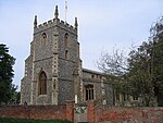
St. Mary's church at Reed geograph.org.uk 389373

Reed is a small village and civil parish in North Hertfordshire. It is situated on a chalk ridge, approximately 3 miles (4.8 km) south of the market town of Royston. The Prime Meridian passes just to the east of the village, between Reed and Barkway. The modern A10 road (here following the course of the Roman Ermine Street) passes just to the west of the village. The population of the parish was 310 at the time of the 2011 census.Reed has a first school, and following a short inspection on 23 March 2017, the judgement of Ofsted was that the school continues to be ‘good’. There is also a village hall, the Saxon parish church of St. Mary, a small chapel (now closed and in private ownership), a cricket club, and a village pub and restaurant set in a 16th-century coaching inn which is currently closed pending planning applications. A converted windmill also stands in the village. There has reportedly been a settlement at Reed for 2,000 years, and the community was mentioned in the Domesday Book of 1086 (as Retth). A number of houses in the village have the remnants of ancient moats, and the village includes a number of ancient woods on its outskirts. Reed was awarded protected status as a conservation area in 1974.

Excerpt from the Wikipedia article Reed, Hertfordshire (License: CC BY-SA 3.0, Authors, Images).

Reed, Hertfordshire
High Street, North Hertfordshire

Geographical coordinates (GPS) Address Nearby Places
placeShow on map

Wikipedia: Reed, HertfordshireContinue reading on Wikipedia

Geographical coordinates (GPS)

Latitude Longitude
N 52.0066 ° E -0.0143 °
placeShow on map

Address

High Street

High Street
SG8 8AH North Hertfordshire
England, United Kingdom
mapOpen on Google Maps

St. Mary's church at Reed geograph.org.uk 389373
Share experience

Nearby Places

River Quin
River Quin

The River Quin is a small watercourse which rises near Barkway in north east Hertfordshire, England. The river is fed by a number of sources including springs from Biggin Moor, Great Hormead Brook, Little Hormead Brook and various field ditches, including the Braughing Bourne - the site of a former glacier from the Ice Age. It flows south, close to the B1368 road to the southwest of Braughing where it joins the River Rib at Gatesbury. This area was the site of a former Roman settlement. Until recently the river was diverted at this point to irrigate watercress beds before flowing into the Rib. The Quin Valley also includes the villages of Hare Street and Great Hormead as well as the smaller settlements of Hay Street and Dassels. The valley is shallow around the river with gently sloping sides at the northern end, becoming slightly narrower with steeper sides at the southern end of the area. Its sides are dominated by open arable farmland in small to medium fields with some occasional large fields particularly at the northern end. There is an absence of woodland and few mature trees grow alongside the river.In Braughing, there are two ford crossings, one at Sheeps Lane and the other at Maltings Lane. The river is prone to severe flooding after heavy rain, rendering the fords impassable, particularly in the autumn and winter months. In 1922, a donkey and cart were swept away when its owner tried in vain to cross Sheeps Lane Ford. The animal was drowned.