place

Milford, New Jersey

1911 establishments in New JerseyBorough form of New Jersey governmentBoroughs in Hunterdon County, New JerseyMilford, New JerseyNew Jersey populated places on the Delaware River
Populated places established in 1911Use American English from May 2020Use mdy dates from May 2020
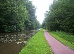
Bridge Street, Milford, NJ by Railroad Avenue

Milford is a borough located in western Hunterdon County, in the U.S. state of New Jersey. As of the 2020 United States census, the borough's population was 1,232, a decrease of one person (−0.1%) from the 2010 census count of 1,233, which in turn reflected an increase of 38 (+3.2%) from the 1,195 counted at the 2000 census.Milford was incorporated as a borough by an act of the New Jersey Legislature on April 15, 1911, from portions of Holland Township, based on the results of a referendum held on May 8, 1911. The borough's incorporation was confirmed on March 13, 1925.The borough is located on the Delaware River in the western portion of Hunterdon County, known as the Hunterdon Plateau. The Borough dates to the mid-18th century when a grist mill was established beside a river in what was then Bethlehem Township. After the mill was destroyed by fire in 1769, the settlement became known as Burnt Mills in Alexandria Township. The area was renamed as "Lowreytown" after Thomas Lowrey purchased land in the area in 1796. The community became commonly known as "Millford" or "Millsford" by the beginning of the 19th century, but by 1844 the name had lost a letter or two. By 1863 it was consistently spelled as "Milford". The community was incorporated in 1911 but the official incorporation was not registered until 1925.

Excerpt from the Wikipedia article Milford, New Jersey (License: CC BY-SA 3.0, Authors, Images).

Milford, New Jersey
Frenchtown Road,

Geographical coordinates (GPS) Address Nearby Places
placeShow on map

Wikipedia: Milford, New JerseyContinue reading on Wikipedia

Geographical coordinates (GPS)

Latitude Longitude
N 40.568611111111 ° E -75.094444444444 °
placeShow on map

Address

Frenchtown Road

Frenchtown Road
08848
New Jersey, United States
mapOpen on Google Maps

Bridge Street, Milford, NJ by Railroad Avenue
Share experience

Nearby Places

Bridgeton Township, Bucks County, Pennsylvania

Bridgeton Township is a township in Bucks County, Pennsylvania, United States. The population was 1,277 at the 2010 census. The township was originally a part of adjacent Nockamixon Township, but a division was arranged and signed on May 24, 1890. This accord split an area of Nockamixon which ran west from the banks of the Delaware River to approximately one third the breadth of the original township. This smaller area was named "Bridgeton", as it was the site of Upper Black Eddy-Milford Bridge covered wooden truss bridge built in 1842, which connected the towns of Upper Black Eddy and Milford, New Jersey. The original covered bridge was replaced by a truss bridge in 1933. The township originally contained several tiny hamlets, such as the aforementioned Upper Black Eddy, Narrowsville, and Rupletown. Upper Black's Eddy, as it was originally called, and Raubsville were named for notable landholders, while Narrowsville was named for a particularly thin portion of the Delaware River. With the construction of a centralized post office in Upper Black Eddy, the usage of separate names for the smaller towns ceased in an official capacity, and the everyday errands of residents became centered on the largest of the towns. What little commercial trade exists in the township is now centered solely in Upper Black Eddy, with any evidence of there being any distinctive, smaller villages existing only on outdated road-signs and maps. Ringing Rocks Park is located within the township, as well as state game hunting lands. Bridgeton Township is also home to the Homestead General Store, the oldest continually operating general store on the Delaware Canal.

Hunterdon Plateau
Hunterdon Plateau

Hunterdon Plateau is a plateau in western Hunterdon County, New Jersey. It borders the higher Musconetcong Mountain to the northwest, the Delaware River to the west, Amwell Valley to the south and the lower lying areas of the Newark Basin to the east. The plateau's edge follows a line from Raven Rock to Flemington. From there it follows a curved path west of the South Branch Raritan River until it meets with the Musconetcongs. It is generally unmarred as a plateau, excluding some of the small valleys of tributaries along the Delaware, of Lopatcong Creek and Wickecheoke Creek and Cakepoulin/Capoolong Creek Valley. Other features are Thatcher's Hill and Sand Hill which form southeastward extensions to the plateau due to a valley of Walnut Brook and the curve of the plateau there. This also occurs between Lockatong Valley and the Delaware River. A small ridge called Barren Ridge runs through Alexandria and Union Township rises slightly above the rest of the plateau. Another feature in Holland Township called Gravel Hill also rises above the rest of the plateau. There are numerous cliffs along the Delaware where the plateau meets it such as Milford Bluffs where prickly pear cacti grow, a rarity in Hunterdon County. The plateau includes the boroughs of Milford and Frenchtown, as well as part of the borough of Flemington and parts of Kingwood, Raritan, Franklin, Union, Bethlehem, Alexandria, Delaware, and Holland townships. Because of the soil types and relatively flat terrain on the plateau, there are still many farms across the area.