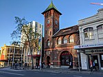
Croydon, New South Wales

Croydon is a suburb in the Inner West of Sydney, in the state of New South Wales, Australia. It is located 9 kilometres (5.6 mi) west of the Sydney central business district. Croydon is split between the two local government areas of Municipality of Burwood and the Inner West Council. The suburb is nestled between the commercial centres of Ashfield and Burwood. It is bounded by Parramatta Road to the north, Iron Cove Creek to the east, Arthur Street to the south and a number of different streets to the west. To the north are Kings and Canada Bays on the closest reach of the Parramatta River, to the northwest is Concord Hospital and the Olympic Games complex at Homebush Bay. To the south is Canterbury Racecourse. The suburb shares its name with Croydon, a large district and borough in the south of London in the United Kingdom. The traditional owners of the land on which Croydon is situated are the Wangal people of the Eora nation.
Excerpt from the Wikipedia article Croydon, New South Wales (License: CC BY-SA 3.0, Authors, Images).Croydon, New South Wales
Young Street, Sydney Croydon
Geographical coordinates (GPS) Address Website Nearby Places Show on map
Geographical coordinates (GPS)
| Latitude | Longitude |
|---|---|
| N -33.87904 ° | E 151.11553 ° |
Address
Croydon Public School
Young Street 39
2132 Sydney, Croydon
New South Wales, Australia
Open on Google Maps


