place

Woodmancote, Horsham District

Civil parishes in West SussexHorsham DistrictVillages in West SussexWest Sussex geography stubs
St Peter's church, Woodmancote

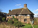
Woodmancote is a village and civil parish in the Horsham District of West Sussex, England. The village is 1 mile (1.5 km) southeast of Henfield on the A281 road. It should not be confused with the other West Sussex village of Woodmancote near Chichester. This scattered community has no village centre. The parish includes the hamlet of Blackstone. The Anglican parish church, St Peter's, which stands alone beside the A281 road, dates to the thirteenth century, and was largely rebuilt in 1868. Close to the church is Woodmancote Place, a large house used as a country club. There is also a parish hall. Woodmancote is recorded in the Domesday Book of 1086 as "Odemancote". Two of the Lewes martyrs, burnt at the stake in the Marian Persecutions of 1556, Thomas Harland and John Oswald, came from Woodmancote.The parish has a land area of 849 hectares (2096 acres). In the 2001 census 478 people lived in 189 households, of whom 248 were economically active. At the 2011 Census the population was 543.

Excerpt from the Wikipedia article Woodmancote, Horsham District (License: CC BY-SA 3.0, Authors, Images).

Woodmancote, Horsham District
Bramlands Lane,

Geographical coordinates (GPS) Address Nearby Places
placeShow on map

Wikipedia: Woodmancote, Horsham DistrictContinue reading on Wikipedia

Geographical coordinates (GPS)

Latitude Longitude
N 50.91872 ° E -0.24441 °
placeShow on map

Address

Bramlands Lane

Bramlands Lane
BN5 9RX
England, United Kingdom
mapOpen on Google Maps

St Peter's church, Woodmancote
Share experience

Nearby Places

Horton Clay Pit
Horton Clay Pit

Horton Clay Pit is a 0.4-hectare (0.99-acre) geological Site of Special Scientific Interest in Small Dole in West Sussex. It is a Geological Conservation Review site. It was once much bigger and a popular area for looking for fossils and many marine creatures have been found in the Gault Clay by professional and amateur fossil hunters alike, especially molluscs - ammonites and belemnites, bivalves and gastropods.This site displays a thick and stratigraphically important sequence of rocks dating to the Folkestone Beds of the Early Cretaceous. It shows evidence of a major structural basin which controlled sedimentation in the western Weald.In 1913 a series of beetle fossils were recovered from its peaty bed. Researchers have used these fossils to suggest a detailed picture of the local environment during the Weichselian glaciation period and have concluded that a sour pool existed here in open heathland with a few coniferous trees. Through Mutual Climatic Range analysis they have predicted that although July was only a mean 1 degree cooler, January was 6 degree cooler.In 1991, the clay pit was granted planning consent for restoration using landfilling. The landfill lies on one side of a shallow excavation with the SSSI lying on the other side. More recently plans have been drawn to bury the SSSI with inert infill to prevent further erosion. This has been agreed in principle by Natural England if the Gault Clay is protected by a marker layer. Additional grassland and woodland planting have been promised that will enable habitat linkages across the restored landfill.