Henfield

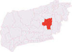
Henfield is a large village and civil parish in the Horsham District of West Sussex, England. It lies 41 miles (66 km) south of London, 12 miles (19 km) northwest of Brighton, and 30 miles (48 km) east northeast of the county town of Chichester at the road junction of the A281 and A2037. The parish has a land area of 4,285 acres (1,734.1 ha). In the 2001 census 5,012 people lived in 2,153 households, of whom 2,361 were economically active. Other nearby towns include Burgess Hill to the east and Shoreham-by-Sea to the south. The population at the 2011 Census was 5,349.Just west of the town, the two branches of the River Adur, the western Adur and the eastern Adur, meet at Betley Bridge. From Henfield the Adur flows on into the English Channel at Shoreham-by-Sea.Henfield was already a large village, of 52 households, at the time of Domesday (1086).
Excerpt from the Wikipedia article Henfield (License: CC BY-SA 3.0, Authors, Images).Henfield
Church Lane,
Geographical coordinates (GPS) Address Nearby Places Show on map
Geographical coordinates (GPS)
| Latitude | Longitude |
|---|---|
| N 50.933 ° | E -0.277 ° |
Address
Church Lane
BN5 9NY
England, United Kingdom
Open on Google Maps


