place

Veierland

FærderIslands of Vestfold
Fähranleger Veierland

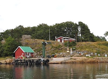
Veierland is a populated, car-free island in Færder Municipality in Vestfold county, Norway. The 4.4-square-kilometre (1.7 sq mi) island is located in the Tønsbergfjorden, between the mainland (to the west), the island of Tjøme (to the east), and the island of Nøtterøy (to the northeast). Veierland Church was established in 1905. Historically, there was a Veierland School, however this closed in 2013. Veierland is primarily a summer vacation community. The island has a 17-kilometre (11 mi) shoreline with many popular swimming beaches including Kjølholmen, Hverveodden, and Kongshavn. Places for accommodation and eateries are open during the summer months.Veierland has been inhabited as long as Vestfold county. The island has a permanent year-round population of about 150 people, however, the island experiences significant summer tourism. Over 450 vacation homes can be found on the island. The island has no bridge or road connections. Veierland is connected to the mainland by 9-17 daily ferries from Tenvik on the island of Nøtterøy via the Jutøya AS. During the summer months there are also ferries from Engø peninsula in Sandefjord Municipality. Convenience stores, a golf course, and restaurants are operated on the island during summers, although most services are closed outside the tourist season. The island is primarily car-free, but residents may acquire permits for vehicles such as tractors, golf carts, mopeds, and ATVs. Besides its boat harbors, beaches, and cabin communities, the island remains densely forested with much agricultural activity.

Excerpt from the Wikipedia article Veierland (License: CC BY-SA 3.0, Authors, Images).

Veierland
Såta, Færder

Geographical coordinates (GPS) Address Nearby Places
placeShow on map

Wikipedia: VeierlandContinue reading on Wikipedia

Geographical coordinates (GPS)

Latitude Longitude
N 59.14858 ° E 10.33719 °
placeShow on map

Address

Såta 17
3144 Færder
Norway
mapOpen on Google Maps

Fähranleger Veierland
Share experience

Nearby Places

Sundås battery
Sundås battery

Sundås battery (Norwegian: Sundås batteri) is a defunct coastal artillery site located at Sundåsen in Sandefjord Municipality (historically part of Stokke Municipality) in Vestfold county, Norway. The fortifications were constructed in 1899 during turbulent times with Sweden during the Union between Sweden and Norway. It was part of the newly established Norwegian Coastal Artillery (Kystartilleriet). The fort was erected to keep potential enemies from entering the Tønsberg area by sea, and was also meant to protect the Marine harbor in the village of Melsomvik. Work on the fort began in 1897, and the forts at both Håøya Island and Sundåsen were completed in 1899. Trenches, commando posts, fencing, concrete gun pits, and other remains from the fort can still be seen at Sundås. The fort lies by the Tønsbergfjorden with surrounding views of Færder Lighthouse and islands such as Håøya, Tjøme, Veierland, and Nøtterøy. The cannons were dismantled by German occupational forces in 1942 during the German occupation of Norway and moved to other fortifications elsewhere in Norway. After the war, the battery reverted to the Norwegian Armed Forces who managed the property until 1962 when an agreement for maintenance and management was made with the municipality in return for public access. In 2005, the area was sold off to Stokke municipality.The fortifications were originally constructed to protect the marine harbor in Melsomvik from a potential Swedish invasion. Views from the fort include the Tønsbergfjord, the Swedish coastline in the east, and the Skrim mountains in the west.

Natholmen
Natholmen

Natholmen or Nattholmen is an island in Sandefjord Municipality in Vestfold county, Norway. The island is located in the Tønsbergfjorden at the entrance to the Lahellefjorden. The 0.22-square-kilometre (22 ha; 54-acre) island is situated about 5 kilometres (3.1 mi) to the east of the town of Sandefjord. The island was only accessible by boat until a bridge was installed in 1920 connecting the island to the mainland. The inhabited island is the home to Knattholmen Campground (Knattholmen leirsted), which is the oldest campground in Norway.On 12 August 1923 the YWCA-YMCA (Norwegian: KFUK-KFUM) established the campground on the island. The campground is called Knattholmen, which may have been the original name given to the island.: 219 The island was the largest island in the municipality of Sandefjord prior to the 2017 merger with Andebu and Stokke. It is 900 metres (3,000 ft) long from north to south, and 400 metres (1,300 ft) wide at its widest from east to west. It is located between the Lahellefjord and the Tønsbergfjord. It is 6 kilometres (3.7 mi) east of the centre of the city of Sandefjord, and immediately south of the Årø peninsula. The island is a gated community that is connected to the mainland by a private bridge. However, there is a parking lot by the gate, which can be accessed by pedestrians. There is also a public bus route to the island (route 163). Attractions on the island include Sandbukta ("sand bay"), which is a beach on its eastern side. It is also a common destination for recreational activities such as camping, paddling, sea trout fishing, hiking, and sailing. It has surrounding views of the Tønsbergfjord and the nearby Stauper islands. A former customs station on the island, known as Blåsen, has also become a landmark. The island hosts annual summer camps for the Queer Youth Festival and the YWCA-YMCA Guides and Scouts of Norway.