Broek, Gouda
Former municipalities of South HollandSouth Holland geography stubs
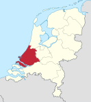
Broek was a municipality in the Dutch province of South Holland, located west and north of Gouda. A longer name of the municipality, Broek, Bloemendaal, Broekhuizen, Thuil en het Weegje names the polders that are part of the municipality. Broek was a separate municipality between 1817 and 1870, when it became part of Waddinxveen. The polder "Broek" is now part of the municipality of Gouda, as is part of Bloemendaal. Around 1850, the municipality had a population of more than 1300, on an area of 17.55 km².,
Excerpt from the Wikipedia article Broek, Gouda (License: CC BY-SA 3.0, Authors).Broek, Gouda
Pad van Tuil,
Geographical coordinates (GPS) Address Nearby Places Show on map
Geographical coordinates (GPS)
| Latitude | Longitude |
|---|---|
| N 52.016111111111 ° | E 4.6741666666667 ° |
Address
Pad van Tuil
Pad van Tuil
2809 ND
South Holland, Netherlands
Open on Google Maps


